“A Week in the Wilderness” by Henry Jarvis Raymond 1855

Harold Jarvis Raymond

Among the many who visited Matthew Beach and William Wood on Indian Point, Henry Jarvis Raymond is notable as the founder of The New York Times.  Raymond was also the elected Lt. Governor of New York State in the summer of 1855 when he travelled through the region.  He published four letters detailing his Week in the Wilderness.   I have republished here his second letter which describes his time at Raquette Lake and at the Iron Works in Adirondac (present day Tahawus).

WiW1

WIW2

WIW3

WIW4

WIW5

WIW6

WIW7

WIW8

WIW9

WIW10

WIW11

WIW12

WIW13

WIW14

WIW15

WIW16

WIW17

WIW18


First News Report of The “Forever Wild” Amendment to the NY State Constitution in 1894

Screen Shot 2015-05-04 at 9.06.28 PM

It is ironic that the same act which has protected the Adirondack Forest Preserve for over one hundred years actually took away the similar protection from a different region of the state.  Beginning in 1821, Article 7 Section 7 had read “the Legislature shall never sell or dispose of the salt springs belonging to this State.”

This constitutionally protected the Onondaga Salt Springs near Syracuse which from the late 1790s through most of the 19th century produced the majority of salt used throughout the U.S.  The State wanted to protect this vital economic resource.  That is until cheaper sources of salt in Michigan and Canada made the Salt Springs an economic drain on the State treasury.  Hopefully the economic value of the protection of the Adirondack Forest Preserve will remain unequivocally positive for the State of New York.

Screen Shot 2015-05-04 at 9.20.30 PM

Here I re-publish one of the first newspaper articles detailing the “Forever Wild” amendment which was unanimously approved by the convention delegates on September 13, 1894 and later approved as part of the new constitution by the state voters in November of that year.

Rochester Democrat and Chronicle title

R Dem Chron 2

R Dem Chron 3

R Dem Chron 4

R Dem Chron 5

1850 – The Raquette River is Declared a Public Highway


raq river log drive

Log Drive on Raquette River. Published by Jon Kopp in Tupper Lake – Images of America


Prior to his visit to Matthew Beach and William Wood’s cabins on Indian Point in 1855, Henry Jarvis Raymond was instrumental in securing the funding from the New York State Assembly to make the necessary infrastructure improvements to turn the Raquette River and the Moose River into public highways for the transportation of logs through the vast wilderness of the Adirondacks.  Here is a reprint of the 1850 NYS Assembly committee report which led to this achievement as published in the March 1, 1850 edition of the New York Morning Courier.

raymond 1

raymond 2

raymond 3

raymond 4

raymond 5

raymond 6

raymond 7

raymond 8

raymond 9

raymond 10

raymond 11

raymond 12

raymond 13

raymond 14

a line of text is missing from the bottom edge of the newspaper


raymond 15raymond 16raymond 17raymond 18

raymond 19

Ralph Waldo Emerson’s ———“The Adirondacs”

Stillman Philosophers Camp

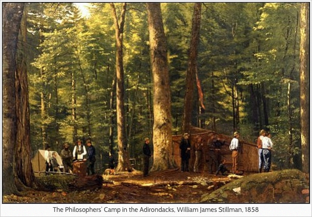
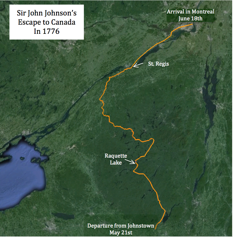
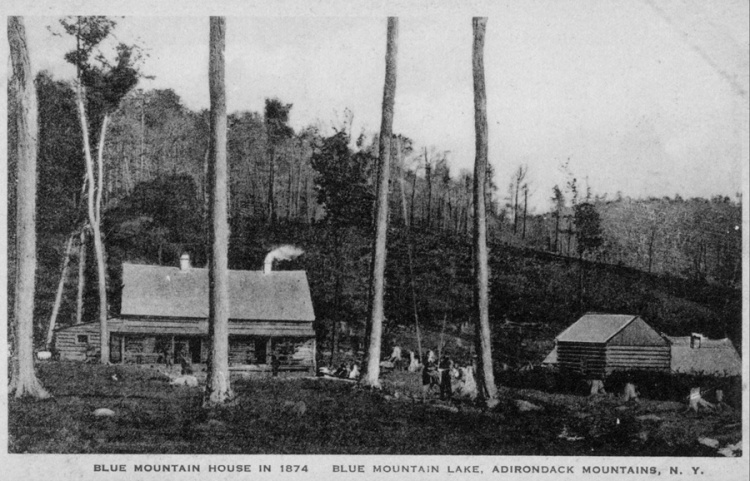
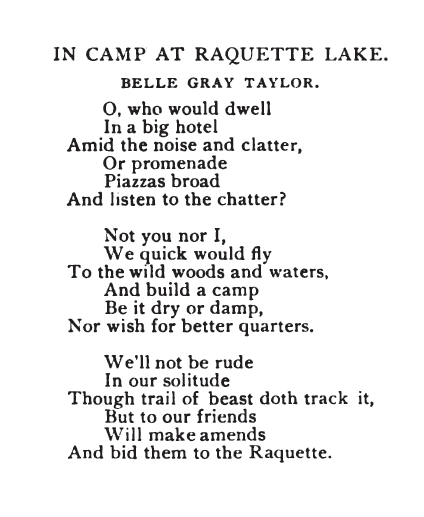
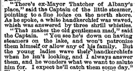
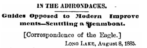
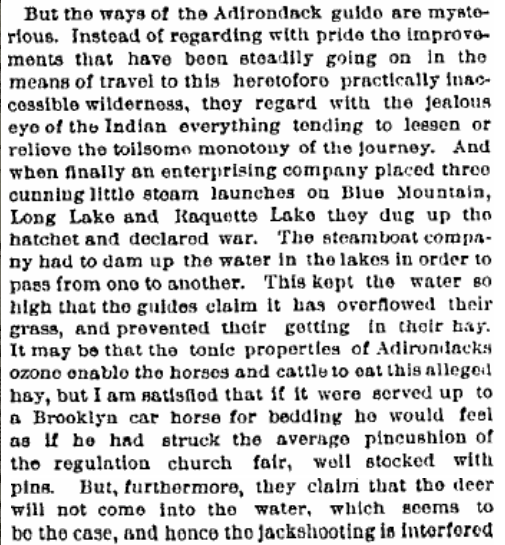
A JOURNAL DEDICATED TO MY FELLOW TRAVELERS IN AUGUST, 1858

Wise and polite,–and if I drew
Their several portraits, you would own
Chaucer had no such worthy crew,
Nor Boccace in Decameron.

We crossed Champlain to Keeseville with our friends,
Thence, in strong country carts, rode up the forks
Of the Ausable stream, intent to reach
The Adirondac lakes. At Martin’s Beach
We chose our boats; each man a boat and guide,–
Ten men, ten guides, our company all told.

Next morn, we swept with oars the Saranac,
With skies of benediction, to Round Lake,
Where all the sacred mountains drew around us,
Tahawus, Seaward, MacIntyre, Baldhead,
And other Titans without muse or name.
Pleased with these grand companions, we glide on,
Instead of flowers, crowned with a wreath of hills.
We made our distance wider, boat from boat,
As each would hear the oracle alone.
By the bright morn the gay flotilla slid
Through files of flags that gleamed like bayonets,
Through gold-moth-haunted beds of pickerel-flower,
Through scented banks of lilies white and gold,
Where the deer feeds at night, the teal by day,
On through the Upper Saranac, and up
Pere Raquette stream, to a small tortuous pass
Winding through grassy shallows in and out,
Two creeping miles of rushes, pads and sponge,
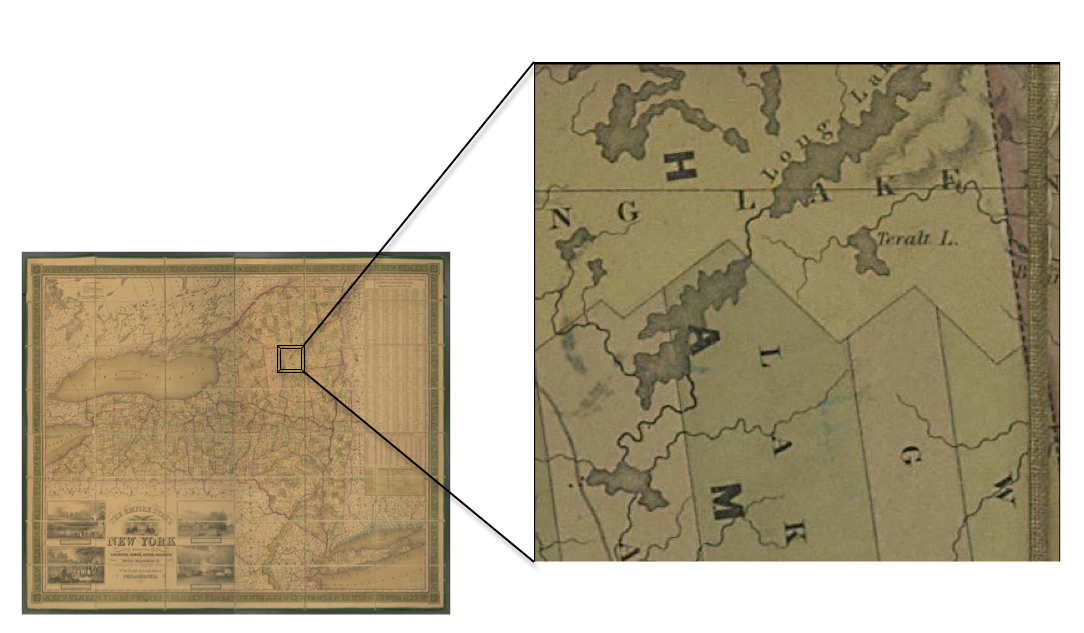
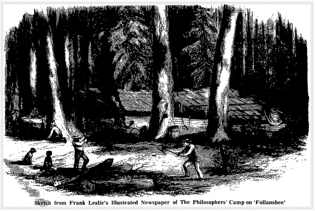
To Follansbee Water and the Lake of Loons.

Northward the length of Follansbee we rowed,
Under low mountains, whose unbroken ridge
Ponderous with beechen forest sloped the shore.
A pause and council: then, where near the head
Due east a bay makes inward to the land
Between two rocky arms, we climb the bank,
And in the twilight of the forest noon
Wield the first axe these echoes ever heard.
We cut young trees to make our poles and thwarts,
Barked the white spruce to weatherfend the roof,
Then struck a light and kindled the camp-fire.

The wood was sovran with centennial trees,–
Oak, cedar, maple, poplar, beech and fir,
Linden and spruce. In strict society
Three conifers, white, pitch and Norway pine,
Five-leaved, three-leaved and two-leaved, grew thereby,
Our patron pine was fifteen feet in girth,
The maple eight, beneath its shapely tower.

‘Welcome!’ the wood-god murmured through the leaves,–
‘Welcome, though late, unknowing, yet known to me.’
Evening drew on; stars peeped through maple-boughs,
Which o’erhung, like a cloud, our camping fire.
Decayed millennial trunks, like moonlight flecks,
Lit with phosphoric crumbs the forest floor.

Ten scholars, wonted to lie warm and soft
In well-hung chambers daintily bestowed,
Lie here on hemlock-boughs, like Sacs and Sioux,
And greet unanimous the joyful change.
So fast will Nature acclimate her sons,
Though late returning to her pristine ways.
Off soundings, seamen do not suffer cold;
And, in the forest, delicate clerks, unbrowned,
Sleep on the fragrant brush, as on down-beds.
Up with the dawn, they fancied the light air
That circled freshly in their forest dress
Made them to boys again. Happier that they
Slipped off their pack of duties, leagues behind,
At the first mounting of the giant stairs.
No placard on these rocks warned to the polls,
No door-bell heralded a visitor,
No courier waits, no letter came or went,
Nothing was ploughed, or reaped, or bought, or sold;
The frost might glitter, it would blight no crop,
The falling rain will spoil no holiday.
We were made freemen of the forest laws,
All dressed, like Nature, fit for her own ends,
Essaying nothing she cannot perform.

In Adirondac lakes
At morn or noon, the guide rows bareheaded:
Shoes, flannel shirt, and kersey trousers make
His brief toilette: at night, or in the rain,
He dons a surcoat which he doffs at morn:
A paddle in the right hand, or an oar,
And in the left, a gun, his needful arms.
By turns we praised the stature of our guides,
Their rival strength and suppleness, their skill
To row, to swim, to shoot, to build a camp,
To climb a lofty stem, clean without boughs
Full fifty feet, and bring the eaglet down:
Temper to face wolf, bear, or catamount,
And wit to trap or take him in his lair.
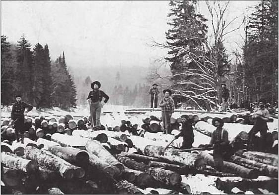
Sound, ruddy men, frolic and innocent,
In winter, lumberers; in summer, guides;
Their sinewy arms pull at the oar untired
Three times ten thousand strokes, from morn to eve.

Look to yourselves, ye polished gentlemen!
No city airs or arts pass current here.
Your rank is all reversed; let men or cloth
Bow to the stalwart churls in overalls:
_They_ are the doctors of the wilderness,
And we the low-prized laymen.
In sooth, red flannel is a saucy test
Which few can put on with impunity.
What make you, master, fumbling at the oar?
Will you catch crabs? Truth tries pretension here.
The sallow knows the basket-maker’s thumb;
The oar, the guide’s. Dare you accept the tasks
He shall impose, to find a spring, trap foxes,
Tell the sun’s time, determine the true north,
Or stumbling on through vast self-similar woods
To thread by night the nearest way to camp?

Ask you, how went the hours?
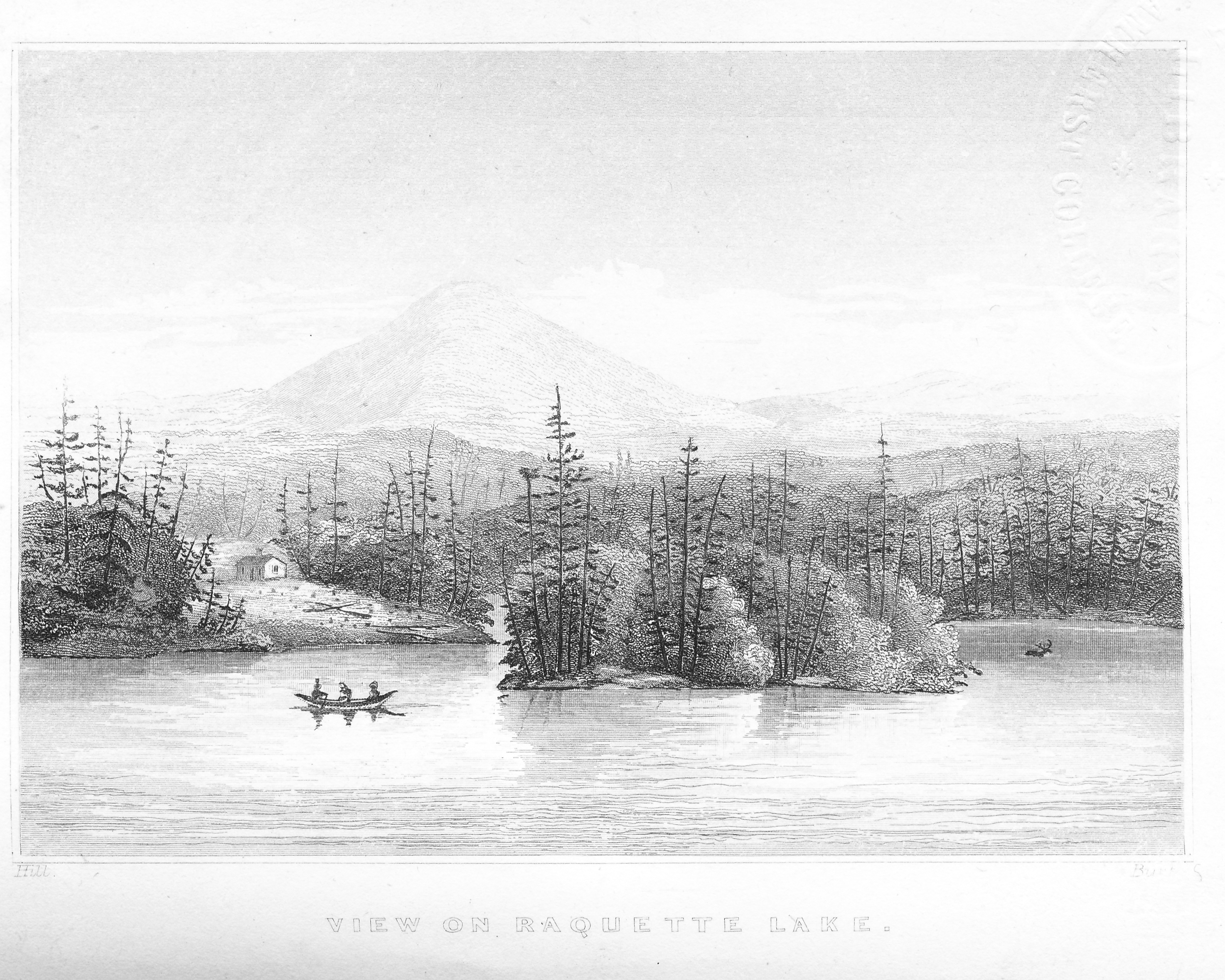
All day we swept the lake, searched every cove,
North from Camp Maple, south to Osprey Bay,
Watching when the loud dogs should drive in deer,
Or whipping its rough surface for a trout;
Or, bathers, diving from the rock at noon;
Challenging Echo by our guns and cries;
Or listening to the laughter of the loon;
Or, in the evening twilight’s latest red,
Beholding the procession of the pines;
Or, later yet, beneath a lighted jack,
In the boat’s bows, a silent night-hunter
Stealing with paddle to the feeding-grounds
Of the red deer, to aim at a square mist.
Hark to that muffled roar! a tree in the woods
Is fallen: but hush! it has not scared the buck
Who stands astonished at the meteor light,
Then turns to bound away,–is it too late?

Our heroes tried their rifles at a mark,
Six rods, sixteen, twenty, or forty-five;
Sometimes their wits at sally and retort,
With laughter sudden as the crack of rifle;
Or parties scaled the near acclivities
Competing seekers of a rumored lake,
Whose unauthenticated waves we named
Lake Probability,–our carbuncle,
Long sought, not found.

Two Doctors in the camp
Dissected the slain deer, weighed the trout’s brain,
Captured the lizard, salamander, shrew,
Crab, mice, snail, dragon-fly, minnow and moth;
Insatiate skill in water or in air
Waved the scoop-net, and nothing came amiss;
The while, one leaden got of alcohol
Gave an impartial tomb to all the kinds.
Not less the ambitious botanist sought plants,
Orchis and gentian, fern and long whip-scirpus,
Rosy polygonum, lake-margin’s pride,
Hypnum and hydnum, mushroom, sponge and moss,
Or harebell nodding in the gorge of falls.
Above, the eagle flew, the osprey screamed,
The raven croaked, owls hooted, the woodpecker
Loud hammered, and the heron rose in the swamp.
As water poured through hollows of the hills
To feed this wealth of lakes and rivulets,
So Nature shed all beauty lavishly
From her redundant horn.

Lords of this realm,
Bounded by dawn and sunset, and the day
Rounded by hours where each outdid the last
In miracles of pomp, we must be proud,
As if associates of the sylvan gods.
We seemed the dwellers of the zodiac,
So pure the Alpine element we breathed,
So light, so lofty pictures came and went.
We trode on air, contemned the distant town,
Its timorous ways, big trifles, and we planned
That we should build, hard-by, a spacious lodge
And how we should come hither with our sons,
Hereafter,–willing they, and more adroit.

Hard fare, hard bed and comic misery,–
The midge, the blue-fly and the mosquito
Painted our necks, hands, ankles, with red bands:
But, on the second day, we heed them not,
Nay, we saluted them Auxiliaries,
Whom earlier we had chid with spiteful names.
For who defends our leafy tabernacle
From bold intrusion of the travelling crowd,–
Who but the midge, mosquito and the fly,
Which past endurance sting the tender cit,
But which we learn to scatter with a smudge,
Or baffle by a veil, or slight by scorn?
Leslies Philosophers Camp
Our foaming ale we drank from hunters’ pans,
Ale, and a sup of wine. Our steward gave
Venison and trout, potatoes, beans, wheat-bread;
All ate like abbots, and, if any missed
Their wonted convenance, cheerly hid the loss
With hunters’ appetite and peals of mirth.
And Stillman, our guides’ guide, and Commodore,
Crusoe, Crusader, Pius Aeneas, said aloud,
“Chronic dyspepsia never came from eating
Food indigestible”:–then murmured some,
Others applauded him who spoke the truth.

Nor doubt but visitings of graver thought
Checked in these souls the turbulent heyday
‘Mid all the hints and glories of the home.
For who can tell what sudden privacies
Were sought and found, amid the hue and cry
Of scholars furloughed from their tasks and let
Into this Oreads’ fended Paradise,
As chapels in the city’s thoroughfares,
Whither gaunt Labor slips to wipe his brow
And meditate a moment on Heaven’s rest.
Judge with what sweet surprises Nature spoke
To each apart, lifting her lovely shows
To spiritual lessons pointed home,
And as through dreams in watches of the night,
So through all creatures in their form and ways
Some mystic hint accosts the vigilant,
Not clearly voiced, but waking a new sense
Inviting to new knowledge, one with old.
Hark to that petulant chirp! what ails the warbler?
Mark his capricious ways to draw the eye.
Now soar again. What wilt thou, restless bird,
Seeking in that chaste blue a bluer light,
Thirsting in that pure for a purer sky?

And presently the sky is changed; O world!
What pictures and what harmonies are thine!
The clouds are rich and dark, the air serene,
So like the soul of me, what if ‘t were me?
A melancholy better than all mirth.
Comes the sweet sadness at the retrospect,
Or at the foresight of obscurer years?
Like yon slow-sailing cloudy promontory
Whereon the purple iris dwells in beauty
Superior to all its gaudy skirts.
And, that no day of life may lack romance,
The spiritual stars rise nightly, shedding down
A private beam into each several heart.
Daily the bending skies solicit man,
The seasons chariot him from this exile,
The rainbow hours bedeck his glowing chair,
The storm-winds urge the heavy weeks along,
Suns haste to set, that so remoter lights
Beckon the wanderer to his vaster home.

With a vermilion pencil mark the day
When of our little fleet three cruising skiffs
Entering Big Tupper, bound for the foaming Falls
Of loud Bog River, suddenly confront
Two of our mates returning with swift oars.
One held a printed journal waving high
Caught from a late-arriving traveller,
Big with great news, and shouted the report
For which the world had waited, now firm fact,
Of the wire-cable laid beneath the sea,
And landed on our coast, and pulsating
With ductile fire. Loud, exulting cries
From boat to boat, and to the echoes round,
Greet the glad miracle. Thought’s new-found path
Shall supplement henceforth all trodden ways,
Match God’s equator with a zone of art,
And lift man’s public action to a height
Worthy the enormous cloud of witnesses,
When linked hemispheres attest his deed.
We have few moments in the longest life
Of such delight and wonder as there grew,–
Nor yet unsuited to that solitude:
A burst of joy, as if we told the fact
To ears intelligent; as if gray rock
And cedar grove and cliff and lake should know
This feat of wit, this triumph of mankind;
As if we men were talking in a vein
Of sympathy so large, that ours was theirs,
And a prime end of the most subtle element
Were fairly reached at last. Wake, echoing caves!
Bend nearer, faint day-moon! Yon thundertops,
Let them hear well! ’tis theirs as much as ours.

A spasm throbbing through the pedestals
Of Alp and Andes, isle and continent,
Urging astonished Chaos with a thrill
To be a brain, or serve the brain of man.
The lightning has run masterless too long;
He must to school and learn his verb and noun
And teach his nimbleness to earn his wage,
Spelling with guided tongue man’s messages
Shot through the weltering pit of the salt sea.
And yet I marked, even in the manly joy
Of our great-hearted Doctor in his boat
(Perchance I erred), a shade of discontent;
Or was it for mankind a generous shame,
As of a luck not quite legitimate,
Since fortune snatched from wit the lion’s part?
Was it a college pique of town and gown,
As one within whose memory it burned
That not academicians, but some lout,
Found ten years since the Californian gold?
And now, again, a hungry company
Of traders, led by corporate sons of trade,
Perversely borrowing from the shop the tools
Of science, not from the philosophers,
Had won the brightest laurel of all time.
‘Twas always thus, and will be; hand and head
Are ever rivals: but, though this be swift,
The other slow,–this the Prometheus,
And that the Jove,–yet, howsoever hid,
It was from Jove the other stole his fire,
And, without Jove, the good had never been.
It is not Iroquois or cannibals,
But ever the free race with front sublime,
And these instructed by their wisest too,
Who do the feat, and lift humanity.
Let not him mourn who best entitled was,
Nay, mourn not one: let him exult,
Yea, plant the tree that bears best apples, plant,
And water it with wine, nor watch askance
Whether thy sons or strangers eat the fruit:
Enough that mankind eat and are refreshed.

We flee away from cities, but we bring
The best of cities with us, these learned classifiers,
Men knowing what they seek, armed eyes of experts.
We praise the guide, we praise the forest life:
But will we sacrifice our dear-bought lore
Of books and arts and trained experiment,
Or count the Sioux a match for Agassiz?
O no, not we! Witness the shout that shook
Wild Tupper Lake; witness the mute all-hail
The joyful traveller gives, when on the verge
Of craggy Indian wilderness he hears
From a log cabin stream Beethoven’s notes
On the piano, played with master’s hand.
‘Well done!’ he cries; ‘the bear is kept at bay,
The lynx, the rattlesnake, the flood, the fire;
All the fierce enemies, ague, hunger, cold,
This thin spruce roof, this clayed log-wall,
This wild plantation will suffice to chase.
Now speed the gay celerities of art,
What in the desert was impossible
Within four walls is possible again,–
Culture and libraries, mysteries of skill,
Traditioned fame of masters, eager strife
Of keen competing youths, joined or alone
To outdo each other and extort applause.
Mind wakes a new-born giant from her sleep.
Twirl the old wheels! Time takes fresh start again,
On for a thousand years of genius more.’

The holidays were fruitful, but must end;
One August evening had a cooler breath;
Into each mind intruding duties crept;
Under the cinders burned the fires of home;
Nay, letters found us in our paradise:
So in the gladness of the new event
We struck our camp and left the happy hills.
The fortunate star that rose on us sank not;
The prodigal sunshine rested on the land,
The rivers gambolled onward to the sea,
And Nature, the inscrutable and mute,
Permitted on her infinite repose
Almost a smile to steal to cheer her sons,
As if one riddle of the Sphinx were guessed.

The Triangulation of Verplanck Colvin

Few fully understand what the Adirondack wilderness really is. It is a mystery even to those who have crossed and recrossed it by boats along it avenues, the lakes; and on foot through its vast and silent recesses…In this remote section, filed with the most rugged mountains, where unnamed waterfalls pour in snowy tresses from the dark overhanging cliffs…the adventurous trapper or explorer must carry upon his back his blankets and heavy stock of food. Yet, though the woodsman may pass his lifetime in some of the wilderness, it is still a mystery to him. 1

 Verplanck Colvin, Superintendent of the Adirondack Survey

 Colvin oval photo


Between 1872 and 1900, perhaps no man traversed the Adirondacks more than Verplanck Colvin.  Russell Carson said, “With limitless enthusiasm and boundless devotion, he was exploring, surveying, mapping, and sketching the mountains, valleys, lakes and streams of the region, and writing voluminous reports and papers about them.” 2  Through his sheer personal will, he succeeded in lobbying the state legislature to appropriate funds for the Adirondack Survey and appoint him to the task. His explorations led to the discovery of Lake Tear of the Clouds as the source of the Hudson River and the first accurate elevations for Mt. Marcy and dozens of other regional peaks.

To map and describe this wonderful region, correcting the errors of early surveyors, and thus furnish a most important contribution to the physical geography of the State, is of course the primary purpose of undertaking the survey. But Mr. Colvin’s elaborate and interesting reports have been largely instrumental in calling the attention of the public to the attractions of the Adirondack wilderness both for the sportsman and the general tourist, and to the importance of taking any measures that may be necessary to preserve it forever as a mammoth pleasure ground. 3

1880 Editorial in The Cultivator and Country Gentleman

Indeed, Verplanck Colvin’s speech at Lake Pleasant in 1868 is credited as the first public advocacy for the preservation of the region as a state park. His later correspondences and reports illustrated his argument:

The Adirondack wilderness contains springs which are the sources of our principal rivers, and the feeders of the canals. Each summer the water supply for these rivers and canals is lessened…The immediate cause has been the chopping and burning off of vast tracts of forest in the wilderness, which have hitherto sheltered from the sun’s heat and evaporation the deep and lingering snows, the brooks and rivulets, and the thick, soaking sphagnous moss which, in times knee-deep, half water and half plant, forms hanging lakes upon the mountain sides…It is impossible for those who have not visited this region to realize the abundance, luxuriance and depth which these peaty mosses – the true source of our rivers – attain under the shade of those dark northern evergreen forests…The remedy for this is an Adirondack park or timber preserve. 4

While Colvin’s impact on the creation of the Adirondack Park is his most lasting achievement, his development of new survey techniques and technology should not be overlooked. It his efforts to unravel the mystery of the forest through detailed mapping that I find fascinating.

Triangulation is the process of determining the location of a point by measuring angles to it from known points at either end of a fixed baseline, rather than measuring distances to the point directly. Colvin used this method to map the Adirondacks using a series of mountain top signal stations.

Colvin was not one to avoid harsh and arduous effort in his attempts to map the Adirondacks. Notably, he did not retire to his Albany office in the dead of winter but rather used the frozen lakes to his advantage.

Raq baseline old

In February 1877, he came to Raquette Lake, as described by The Colvin Crew based on his field notes,

to establish a horizontally measured sub-baseline that could be used to strengthen his primary triangulation network of the Adirondack Mountains. This necessitated finding two points on the shore of Raquette Lake that would allow for the longest possible distance measured. Additionally, both points had to be visible from West Mountain and Blue Mountain. Following standard procedure, Bolt 69 was set on the south shore of Raquette Lake at a location known as Otter Point. With the ice cleared of snow, vertical wood stakes were set into the ice to act as guides in keeping the tape straight.   The 1,000 feet long steel “ribbon” was then stretched northerly with metal “ice blocks” being used at the intermediate chaining points for a total distance of 14,571.95 feet. The northerly terminus of this line was marked with a copper plug set in a small rock located at the northeast end of Needle Island. 5 [approximated in the author drawn map shown below]

Raq baseline google earth

Observations from the end point of such baselines to the mountain top signal stations required Colvin to devise two tools that advanced the accuracy of his methods. The Stan Helio is a spinning pyramid of shiny tin plates that reflect sunlight, providing a bright flash that could be seen in the daytime from twenty-five to thirty miles away with the naked eye and even farther through a telescope.

stan helio

Being able to see the mountain top signal stations from wherever his surveying teams were working was one piece of the puzzle. The other is for the surveying teams to accurately know exactly where they were when they observed the nearest signal station.

Determining a location’s longitude and latitude whether by the arc of the sun in day or by stars at night requires that one know the precise time of observation. The accuracy of Colvin’s surveying depended on all of his field teams synchronizing their timepieces to Albany’s Dudley Observatory time.

Here my research took an interesting turn when I discovered that Colvin’s solution to time synchronization involved my family. In August 1876, Colvin established an observation station on Thacher Island on Blue Mountain Lake. It was from here that he first observed the use of a nighttime powder charge flash signal that would communicate the accurate time to surveyors far afield. As he described

A supply of powder for the signal station time-flash had been sent to the mountain, and at a little before 9 P.M. we took up our station on a point commanding in the day-time view of the distant peak, and prepared to compare our watches with the chronometer signal. As we counted the seconds a bright flash illuminated the darkness, showing the mountain-top fairly, as lit by distant lightning. We found our time accurate, and were now satisfied that this method of distributing the Observatory time to the parties would be an entire success if the atmospheric conditions were favorable. 6

flash-signal

I was intrigued to know why Colvin would have used Thacher Island, when a point along the shoreline would have served just as well and eliminated the effort of rowing boxes of equipment out to the island. I knew that Colvin was from Albany, but did he know the Thacher family? My early hopes of a connection seemed dashed by viewing Colvin’s Reconnaissance Map of Tallow or Blue Mountain Lake, which incorrectly spelled our name as Thatcher. A family friend would never commit such an error.

Thatcher on map

I delved deeper into the accuracy of the map and found that the spelling was an inaccurate correction made by the printer. In Colvin’s own handwritten field notebooks, he repeatedly spells the name correctly.

Thacher in Colvin notes

Triangulation uses math to discover what cannot be readily seen and measured by comparing different points in relation to a baseline. I wondered whether an analogous method of drawing connections between points in time in the lives of Verplanck Colvin and the Thachers might answer my question.

The history of Albany provided the first clues. Verplanck Colvin and John Boyd Thacher were both born in 1847. Colvin’s father Andrew J. Colvin was the State Senator from Albany in 1860-1861 (the same seat occupied by JBT twenty-three years later) at the same time that George Hornell Thacher was the Mayor of Albany; both were prominent Democrats. 7  So their fathers were clearly acquainted, but did the boys know each other? Hilary Johnson King, archivist of Albany Academy, discovered that both boys were classmates in a group of forty students for three years (1858-1861). 8

The Thachers began to explore the Adirondacks in 1862 and established their summer home on Blue Mountain Lake in 1867. Verplanck Colvin began his explorations of the region in 1865. We have no correspondence or other evidence that John Boyd Thacher and Colvin were more than acquaintances in their youth. Colvin does not make reference to the Thachers in describing his earliest camping trips to the region, and yet it is hard to believe he did not consult with the first family from Albany to establish a base in the region.

I found that JBT’s and Colvin’s lives repeatedly intersected throughout the years.

JBT and Colvin timeline2

All of these intersecting points prove that the two men knew each other, but were they friends? Only after JBT’s death do I find evidence that it would appear so.

In 1869, Colvin was the first to bring national attention to an area of scenic beauty and scientific value with his writing and hand-drawn illustrations in Harper’s Magazine 14

To those who desire to escape for a day from the oven-like city in summer; who wish to enjoy a scramble among the romantic cliffs, in shady woods, beside cool mountain brooks and waterfalls; to view spots sacred to legends of wild Revolutionary days, of Tory and Indian depredation, naming place, precipice, and mountain…

One might think that Colvin was once again writing about the Adirondacks here, but the quote continues…

to gather the fossil corals and shells… to visit and explore known caves… among the cliff ledges, the “Indian Ladder” region of the Helderbergs offers superior inducements.

Verplanck Colvin Escarpment Illustration

The Helderberg Escarpment lies about twenty miles to the west of Albany and a two hour drive in 1869 when Colvin used the site as his training ground. The cliffs and fields served as a laboratory where Colvin perfected the self-taught surveying techniques that he applied to the Adirondacks. 15

Beginning in 1903, John Boyd Thacher purchased 300 acres along this escarpment to preserve its invaluable fossil record and intrinsic scenic beauty. After his death, JBT’s wife, Emma Treadwell Thacher, donated the lands to create what today is known as John Boyd Thacher State Park. 16

We might easily assume that Colvin influenced JBT to preserve these lands. However, unlike my previous “triangulations”, no assumption is required here. Within the 1915 annual report of the American Scenic and Historic Preservation Society, a description of the 1914 Dedication Ceremony for the park lists Verplanck Colvin as one of eight dignitaries who enjoyed lunch with Mrs. Thacher at her Altamont estate prior to the ceremony. 17

This is notable for two reasons. None of the numerous daily newspaper articles describing the ceremony mention Colvin’s presence, and he did not speak at the ceremony itself. Having been unceremoniously and a bit scandalously fired from his state position in 1900 by Governor Teddy Roosevelt, Colvin faded into a life of obscurity, became depressed and lived in hermit-like seclusion in his home in Albany. 18

His respected place of inclusion in Mrs. Thacher’s plans for the dedication is, I believe, proof of a lifelong friendship with John Boyd Thacher and furthermore, evidence that Verplanck Colvin deserves credit as the father of two glorious state parks.


—- Sir John Johnson’s Escape —- A Tale Retold

SJJ portait 2

The legend of Sir John Johnson’s role in naming Raquette Lake has been written and re-written for more than a century.   Below is the earliest source I have found, from the 1891 New York State Forest Commission Annual Report. 1

Its name is founded on a bit of history, hitherto traditional. During the War of the Revolution, a party of Indians and British soldiers, under command of Sir John Johnson…passed through the wilderness on their way from the Mohawk Valley to Canada. It was in the winter time, and, on reaching this lake, the party was overtaken by a sudden thaw, which made further travel on snow-shoes impossible. As the Indians and soldiers did not want to carry their snow-shoes, or raquettes, as they termed them, they piled them up and covered them over, making a large heap that remained there many years. The expedition had reached the South Inlet when the thaw set in, and it was there, on a point of land, that the pile was made… Old Mr. Woods, the pioneer settler of Raquette Lake, heard this story from the Indians themselves, and often pointed out to hunters the decaying fragments of the raquettes.

Believing that “Old Mr. Woods” refers to William Wood, I was intrigued to unravel the mysteries of this folklore. Wood was known to be close friends with local Indians, and the passage continues with a reference to Woods “in company with ‘Honest John Plumley’, Murray’s celebrated guide”. Wood sold his land on Indian Point to Plumley in 1859. 2

This folklore makes for a wonderful story, but two doubts are raised.

1) The passage infers that Wood saw the decaying fragments of the raquettes as late as the 1850s, about 75 years after being discarded. How would these fragments have survived so long?

2) Sir John Johnson actually fled Johnstown in late May, not “in the winter time”.   Why would snowshoes have been necessary?

raquettes

Unraveling possible answers to these questions has led me to propose a new theory regarding the timeline and method of Sir John Johnson’s escape.

Nowadays, the ice-out has never been later than the first week of May, and snow cover is gone from the woods by then. However, from 1550 to 1850 a period of significant cooling, termed the Little Ice Age, occurred with three particularly cold intervals, one during the American Revolution. In David Ludlum’s Early American Winters 1604-1820, weather records reveal five Northeast snowstorms occurred in May or June between 1773 and 1777, suggesting that snowshoes in late May is not a literary exaggeration. 3

Exaggerations of other details of Johnson’s escape are quite common, however.   The description offered by William Stone in his 1838 book The Life of Joseph Brant-Thayendanegea has been repeated so often as to take on the air of fact. 4

After nineteen days of severe hardship, the Baronet [Johnson] and his partisans arrived at Montreal in a pitiable condition – having encountered all of suffering that it seemed possible for a man to endure.

This notion that Johnson’s trek to Montreal took only nineteen days does not hold up under scrutiny, and Stone offers no citation.  Johnson did not keep a military diary of these days in the woods.   Historians have not found any primary sources written during the actual escape. Various historians have, however, pieced together the presumed route that Johnson took. The most accepted path is one proposed by J. Yates Van Antwerp, Johnstown Historian, in 1937. 5

According to Van Antwerp, Johnson’s party headed northeast from Johnstown to his family’s summer home, the Fish House on the Sacandaga River, then northwest along the river, passing north of Lake Pleasant and through the West Canada Lakes region to Raquette Lake.   They then followed the Raquette River to Long Lake. North of Long Lake they turned northwest, crossing over to the source of the South Branch of the Grasse River, which led to the St. Lawrence and on to Montreal.   The total distance is approximately 300 miles.   A 19 day trip would mean they averaged almost 16 miles a day. This is highly improbable.

The Continental Army averaged such a pace on the Washington-Rochambeau march from Dobbs Ferry, NY, to Yorktown, VA, in the summer and fall of 1781.  6  Johnson’s party snowshoeing narrow Indian trails and bushwhacking in sections could not have matched an army moving with horses and wagons over open roads.

While there are no primary sources from the escape, there are contemporary letters that shed light on the possible reason for Stone’s 19 day estimate. The only direct information of the escape comes from a letter written by Sir John Johnson to his brother on January 20, 1777.  

Upon my arrival at St. Regis with my party consisting of one hundred and seventy men who were almost starved and wore out for want of provisions, being nine days without anything to subsist upon but wild Onions, Roots and the leaves of Beech Trees [A], I was received in the most friendly manner by the Indians who informed me that the rebells were still in possession of La Chine and Montreal… I proposed to them to go off immediately and attack the former Post. They seemed very hearty, and desired that I would send to Capt. Forster at Oswegatche [Ogdensburg], for two field pieces, which had they had taken at the Cedres, which I did and in a short time received one of the field pieces with a Sergeant, one Artillery Man and three Volunteers, with which I set out after many delays [B]… I was joined by the Indians of the Lake of two Mountains, with many Canadians, but upon my arrival on the Island of Montreal, I was informed that the Rebells had abandoned both places the day before, and that the 29th Regt. had taken possession of Montreal. [C]

This portion of the letter reveals many details of Sir John Johnson’s timeline. The British had retaken possession of Montreal on June 17th [C], so Johnson arrived in the city on June 18th. 8

Three letters serve to identify May 21st as the date of his flight from Johnstown. 9

  • On May 18th, Johnson wrote a letter from Johnson Hall to General Philip Schuyler of the Continental Army in Albany.
  • On May 19th, Col. Dayton arrived at Johnson Hall to arrest Johnson on the orders of Gen. Schuyler and found Johnson had fled into the nearby woods.
  • On Wednesday, May 22nd, Dayton wrote “Sir John, with upwards of three hundred persons, several of whom are said to be armed, attempted on Tuesday morning to make his escape through the woods to Canada.”

Therefore we know for certain that the entire trip from Johnstown to Montreal actually took 29 days. (May 21 – June 18)

SJJ full route

If we work backwards from June 18th, we can estimate when he probably arrived in St. Regis, about 67 miles south of Montreal. Marching with a field piece on open roads to Montreal would have taken a minimum of four days. So the earliest Johnson could have departed St. Regis would have been June 14th.

Prior to departing St. Regis, Johnson had to regain strength from his ordeal in the woods and wait for the arrival of the field piece from Ogdensburg. It is difficult to know how long Johnson stayed in St. Regis. The request for and delivery of the field piece from 45 miles away in Ogdensburg [C] would have taken at least four days. Johnson says he “set out after many delays” after the arrival of the field piece.

If his time in St. Regis had stretched to six days, then the end of his arduous ordeal through the Adirondacks and his salvation among his Indian friends would have come on June 8th, nineteen days after departing Johnstown – perhaps the true origin of Stone’s 1838 account.

Even if we accept that the trek from Johnstown to St. Regis took 19 days, we still know very little about the trip itself. How many miles per day could Johnson’s party have advanced through the snow-covered forests between Johnstown and Raquette Lake? One proxy comes from the details on Adirondack Forum of a through-hike by snowshoe of the Northville-Lake Placid trail in the winter of 2006-2007. The group on that expedition averaged five miles per day.  10   At only five miles per day, it would have taken Johnson 14 days to reach Raquette Lake, requiring them to travel over thirty miles on each of the remaining five days to reach St. Regis.

Of course, the NLP through-hikers were not in fear of a pursuing army. Snowshoe trekkers advise an average of one mile per hour when planning a winter hike.  11  If we assume Johnson’s men pushed themselves ten hours per day, at that pace the time is shortened to seven days. Even so, they then would have had to maintain a pace of over thirteen miles per day from Raquette Lake to St. Regis. While snow cover and snowshoes no longer slowed them, we also know that in the last nine days they were subsisting on wild onions, roots and leaves. [A] Could they have maintained this significantly increased pace as their strength was failing them and the spring thaw yielded to mud season?

If Johnson intended to complete the trek on foot, why did he not follow the long established Mohawk trail which passes to the west of Raquette Lake and leads to the source of the Oswegatchie River? (see Why Indian Point?)

If Johnson’s party were seeking to avoid discovery, why would they create a pile of snowshoes on a prominent point upon the shores of Raquette Lake as opposed to hiding the pile further back in the forest?

What follows is pure conjecture that cannot be proven but does provide answers to these questions while not contradicting any known facts.   While he may have originally intended to march to Montreal, I believe during the hazardous trek to Raquette Lake, Johnson realized it would not be possible. I think he sent word to St. Regis to send a group of Mohawks to aid his escape.

The Iroquois were noted for their use of relay runners who collectively communicated messages over eighty miles in a day.  12  According to William Stone in The Life of Joseph Brant-Thayendanegea, Brant claimed that Mohawks were sent south from St. Regis to aid in Johnson’s escape.  13   Sue Herne of the Akwesasne Museum of the St. Regis Reservation says that today’s Mohawk oral history corroborates this story.  14

Just as Johnson appears to have communicated northward, it would appear that he intentionally created a campaign of misinformation to throw the Continental Army off his track. Col. Dayton believed Johnson was traveling west to Niagara via Oneida Lake. He based this on comments from Sir John Johnson’s wife and testimony of an Oneida Indian on May 23rd who claimed a flotilla of bateau boats were awaiting Johnson at Oneida Lake. He also received intelligence that a road had recently been marked from Johnson Hall to Fort Brewington on Oneida Lake. 15

I believe Mohawk runners could also have brought the news to Johnson that Gen. Schuyler’s scouts had reported finding no trace of them and claimed that the trail to the north was impassible.  16  This would have allowed Johnson time to alter his plan.

Johnson already had three Mohawks guiding his men north when they left Johnstown.  17   However, Van Antwerp’s account speaks of 25 Mohawks aiding the escape.  18  I believe the additional Mohawks were sent south from St. Regis to construct elm bark canoes at Raquette Lake so Johnson could continue his escape by water. Switching to water transport here rather than continuing on the familiar Mohawk trail to the Oswegatchie River, Johnson saved his party another thirty miles of arduous hiking through the forest.

canoe_bark1825

The Iroquois were known to primarily use elm bark canoes. In contrast with birch bark canoes, an elm bark canoe could be built in as little as two days. The process is similar to building a spruce bark canoe (see Mitchell Sabattis-Boatbuilder). Given the cold weather during Johnson’s escape, it was likely necessary to use boiling water to strip the bark from the trees. This slower process might have stretched the construction time to four days.  19

The travel times of the Iroquois using elm bark canoes on various water routes in 1656-1657 are detailed in early records of Jesuit missionaries, which indicate the Iroquois travelled an average of 45 miles per day downstream and 20 upstream. 20

I estimate that Johnson’s party could have travelled 20 miles per day from Raquette Lake through Long Lake and the small streams and portages to the source of the Grasse River, covering this distance in approximately three days. Given their weakened physical condition, I will conservatively estimate a pace of only 35 miles per day paddling downstream on the Grasse River, arriving at St. Regis in another three days.

SJJ Possible Route

Therefore, by water and portages the Johnson party could have made it from Raquette Lake to St. Regis in six days. This leaves thirteen days between fleeing Johnstown and when they departed from Raquette Lake. If four days were devoted to building the canoes, a snowshoe trek pace of only eight miles per day would have been sufficient to reach Raquette Lake in nine days.

I believe the pile of snowshoes was placed on the lakeshore because that is where they departed in the elm bark canoes.   The pile was covered up by the waste from the canoes’ construction. After 75 years of decomposition of this waste layer, the remnants of the snowshoes were still visible to William Wood.

END NOTES


The Capture and Death of Charles Parker

Our family has two large metal boxes filled with George Hornell Thacher’s handwritten letters.   We are fortunate to have three letters written from the Thacher “Camp” on Indian Point.

GHT’s correspondence to his son George Jr. dated August 7, 1881 is a unique piece of history. He references a tragic affair which became the talk of the major NY newspapers.

GHTLetter

                                                                                                Camp, Aug. 7th, 1881

Dear George,

My health is about as usual. Nothing new here of importance except the recapture of Parker yesterday, the desperado, the man who outraged a lady on the carry between Forked and Long Lakes. He was arrested at Lowville while fleeing to Canada and taken back to Long Lake where he got away from the constable. Yesterday the same officer overhauled him on Forked Lake near the outlet, shot and broke his arm and recaptured him. The lady was a sister of the wife of U.S. Senator Platt of Connecticut. Parker was a newcomer here and took up the business of guiding. He was guiding her to Long Lake and perpetrated the deed near Butter Milk Falls.

                                                                           Father

P.S. Parker was shot through the arm and breast. The Doctor says he will die probably before night. The way of the transgressor is hard. 10 A.M.

The Troy Press said, “Probably no event occurring in the Adirondack region has caused as much comment and excitement as the crime that is attributed to Charles Parker.”

On July 23, 1881, Charles Parker was guiding Mrs. George Bull, the wife of a prominent Philadelphia politician, from Blue Mountain Lake to Long Lake via Raquette and Forked lakes. Upon arriving at Senator Platt’s Camp on Long Lake, Mrs. Bull became hysterical and fainted. In the confusion and before she was able to accuse him of sexual assault, Parker fled. He quickly returned to his cabin on Forked Lake, sold his boat and used the proceeds to flee north through Lowville to Kingston, Canada.

Owing to the prominence of the Bull and Platt families, the manhunt for Parker was extensive and rapid. Canadian authorities captured him and returned him to Long Lake’s Constable Cole in Watertown. Cole and the son of Senator Pratt transported Parker to Long Lake, arriving on Tuesday August 2nd. Parker was lodged at Helms Hotel in the physical custody of Constable Cole.

Parker was handcuffed to Cole’s wrist as they lay down to sleep that night in their hotel room’s one bed. In the morning, Cole awoke to find Parker gone with the handcuff still attached to Cole’s wrist. Cole alleged that Parker must have had accomplices for his escape.

The events of the next few days and Parker’s eventual death vary depending on the news source that reported it. What is not in dispute is that Charles Parker was shot near the outlet of Forked Lake on Friday August 5th.

Today we expect our news to travel the world in the blink of an eye as our twitter feed updates. News sometimes took days to reach our ancestors’ ears in the 19th century, and in a rush to put out the news of a rapidly changing story, the facts seemed to change.

The earliest report of the escape, which occurred in the night of Tuesday August 2nd, was in The Syracuse Daily Courier on Monday August 8th. The article makes no mention of his recapture.

On Tuesday August 9th, the Albany Evening Times finally published the news of Parker’s wounding and recapture on the previous Friday. In this account,

At eleven o’clock this morning [Aug 5th], the constable with another man went to the foot of the [Forked] lake, where an interview had been arranged to be held between him and Parker, the constable promising to not arrest or detain the latter when he wished to leave. Parker came to the place of the meeting at the head of the outlet, accompanied by his wife, Cole and his deputy being on the opposite bank. Parker advanced to the center of the river in his boat to speak with the constable. After some conversation, Parker began to pull back to the far shore. Cole called to him, ordering him to surrender or he would shoot. Parker increased the speed of his boat and swung it around so that his wife came between him and the constable. As the boat struck shore, Parker jumped out, and as he was reaching down in the boat for his gun, Cole fired one shot at him…[which] struck Parker’s left arm, about an inch below the shoulder, badly shattering the bone and completely disabling him. It seems that the ball, after striking the arm, entered the breast near the nipple and took a downward course. Dr. Woodruff, who is summering at Raquette Lake, attended the wounded man as quickly as he possibly could, and he states that Parker has but a bare possibility of recovery.

This early account of a negotiation for Parker’s surrender was quickly replaced by a different narrative in subsequent days. The Utica Observer published a letter on August 11th written by James Platt, the senator’s son [who was not a witness] describing Parker’s recapture. Platt claimed,

News was soon had of him as having been seen on his way to Forked Lake. Justice Shaw, Mr. Bull, Cole and others at once started for Forked Lake. After reaching there it became evident that Parker was hidden in the woods and fed by some of his old cronies who live in that vicinity. Friday evening Cole, who had been on watch, discovered Parker in a boat with his wife near the foot of Forked Lake. Cole stepped upon a rock near the shore and called upon Parker to stop and surrender. Parker pulled rapidly toward the opposite shore; Cole repeated his command several times, saying that he would shoot if Parker did not stop…Parker lifted up his rifle from the bottom of the boat. As soon as Cole saw the rifle he fired at Parker’s shoulder, which was the only portion of his body not covered by his wife

Not surprisingly, the Philadelphia Times account published on August 16th embellishes the prominent Philadelphian’s role.

Mr. Bull, who returned to Philadelphia Friday night, brought the first intelligence of the miscreant’s death. He says he would not have left the place with Parker alive, but seeing his lifeless body before him and the coroner’s jury in the act of holding an inquest, he departed satisfied. It was Mr. Bull who tracked Parker to his lair on Friday. During the three days, Mr. Bull had officers and guides scouring the lake, but Parker, from his hiding place on shore, could see their every movement. Mr. Bull finally located him near the foot of Long Lake and stationed Cole and another constable, both armed, at the only point where he could pass in getting away.

The official coroner’s inquest accepted witness testimony which agrees with James Platt’s account while making no mention of Mr. Bull’s direct involvement. It concluded “That he, the said Charles Parker, came to his death on the 9th day of August, 1881, caused by a gun-shot wound fired from a gun in the hands of Warren W. Cole while in discharge of his duties as constable in and for the Town of Long Lake in the County of Hamilton.”

The news of Parker’s recapture reached GHT sometime on August 6th as he wrote about it on August 7th and then I believe added his postscript on the morning of August 8th (hence the 10 AM notation). The Doctor in the letter surely was the Dr. Woodruff mentioned in the newspaper article and perhaps the direct source of GHT’s information.

While the news took days to reach the reading public outside the region, my great great grandfather’s letter shows that local news travelled quite quickly among the guides and summer residents of the region. Word of mouth was almost as rapid as today’s social media but limited to face to face rather than Facebook communication.

Matthew Beach and William Wood

Yonder comes the boat of Woods and Beach, the two solitary dwellers of this region. It is rather a singular coincidence that the only two inhabitants of this wilderness should be named Woods and Beach. I should not wonder if the next comers should be called ‘Hemlock’ and ‘Pine’.

Joel Tyler Headley, The Adirondack or Life in the Woods 1

Beach and Wood’s presence on Indian Point literally put Raquette Lake on the map.  A fact revealed by one of the earliest depictions of Raquette Lake in J. H. Young’s 1845 map of New York State.   The map shows an almost wholly inaccurate depiction of an un-named Raquette Lake, to the southwest of Long Lake. However, it contains a nearly accurate rendering of Indian Point prominently jutting out from the west side of the lake.

1845 Map and Insert

Indian Point was the focal point of the first map of Raquette Lake because Beach and Wood were the center of hospitality for the earliest adventurers travelling through the region. Professor Ebenezer Emmons in 1840, John Todd in 1843, Joel Tyler Headley in 1844-1846.  The tales told by these writers and the early surveys drawn by them undoubtedly contributed to this depiction of Indian Point on the 1845 map. Our knowledge of Beach and Wood come from the writings of these and later prestigious visitors.

Pioneering Settlers

Matthew Beach was the elder of the pair, nearing sixty and almost two decades senior to William Wood when they settled on Indian Point. Both men were Vermonters who appear not to have sought out the Adirondacks as much as fled civilization in the early 1830’s. Headley noted that:

One of them was once a wealthy manufacturer; but overtaken by successive misfortunes, he at length fled to the wilderness, where he has ever since lived. There is also a rumor, of some love adventure—of blasted affections followed by morbid melancholy—being the cause of this strange self-exile. 2

They originally made their livelihood in the region as trappers, according to Henry Jarvis Raymond. Raymond [founder of The New York Times newspaper and Lt. Governor of New York at the time] visited with them in 1855, remarking “They became so fond of the country and the life that they finally settled there, –clearing their land gradually, never troubling about securing their title *, living together in a bark shanty, which with progress of the age grew into a log hut, and obtaining their living mainly by hunting and fishing.” 3  Screen Shot 2014-05-31 at 7.32.48 AM


I have yet to find any photographs of Beach and Wood. However, a vivid picture of each is drawn from the writings of their visitors.

C.W. Webber’s describes Beach in The Spirit of the Times in 1849 as:

The old white haired veteran, yet stalwart and hearty, whose step is still elastic, and eye—eagle-like—bright as ever—coarsely dressed, with a true hunter like air…appeared, indeed, no ordinary woodsman…I found Beach quite intelligent, he has picked up much information in one spot or another, and, no doubt, no small amount from Naturalists who, having occasion to visit that country for the sake of geological exploration…have made his hut their quarters. 4


William James Stillman, describing an 1855 visit in The Crayon said Beach:

is a man of very interesting character, the noblest example of the backwoodsman I have ever seen, simple and pure in feeling as a child. He was a volunteer at the [War of 1812] Battle of Plattsburg, the bloody character of which contrasted strangely with his quiet and gentle deportment. 5

In 1868, B. F. De Costa wrote in a history of Beach:

Matthew Beach, though possessing little book-learning, had nevertheless, acquired a valuable kind of culture. He was a shrewd observer of character, and seldom erred in his judgment of men. He studied closely the habits of animals of the forest, and was a careful student of nature. 6

References to William Wood in the region, place him living with two other bachelors in a house at Herreshoff settlement to the west of Old Forge in 1832. Wood was a witness to the 1833 infamous murder of an Indian named Drid by Nat Foster (a story for another time). 7  At this early date, Wood was a whole man, given that court testimony during Nat Foster’s trial make no reference to the unusual physique and manner of mobility noted in later histories of the man.

In 1849, David Read (co-owner with Farrand Benedict of Township 40) wrote in a letter to Joel Tyler Headley: 8

David Read W Wood description


Raymond remarked about Wood that, “He wears immense shoes—more like boats than brogans—and with these, stumps through the woods at a marvelous pace.” A letter to The Spirit of the Times describing a Constable family trip through Raquette Lake in 1843 said Wood was, “frequently carrying 70 lbs. on his back, and in winter had rather the advantage of him, as with a thick covering of moose hide, his knees answered the purpose of snow-shoes.” 9

The year of Wood’s accident is a mystery. The historian Edith Pilcher claims the accident occurred when Wood fell into the Independence River while returning to his home near Old Forge. Pilcher attributes his survival to being found half-frozen by the very same Nat Foster, whose life Wood had perhaps spared with his evasive testimony during Foster’s murder trial. Local Indian friends of Wood are said to have amputated his legs and nursed him back to health. 10  Given he was whole at the time of the Nat Foster-Drid incident, Wood’s misfortune must have occurred after 1833. The absence of Beach’s character in these stories leads me to conclude that this tragedy befell Wood prior to their joint residence on Indian Point.

The exact year of Beach and Wood’s arrival on Indian Point is also unknown, but it appears to have been between 1835 and 1839. The 1843 Constable family trip described in The Spirit of the Times mentions the “two old hunters who had lived here about eight years” –meaning 1835. Joel Tyler Headley wrote extensively of his 1846 visit with Beach and Wood stating “the two hunters that occupy [two huts] the only inhabitants that are or have been on the shore for the last nine years.” This would correspond to 1837. Stillman in 1855 states that “Mr. Beach has lived here seventeen years”, fixing 1838 as the date. At the second-ever town meeting of Long Lake in 1839, William Wood was elected Assessor and Matthew Beach was elected Commissioner of Common Schools. 11   It is likely that the two were then living together on Indian Point. Therefore, I believe Wood’s accident occurred sometime between 1833 and 1838.

A Hut in the Woods

In 1840, Prof. Ebenezer Emmons and J. W. Hill stayed with Beach and Wood in their hut while surveying the Raquette Lake region for the Survey of the Second Geological District of New York State. 12  During this survey, Hill drew a sketch of their hut that was later published in Headley’s book.

1849 Birch Pt sketch

Various visitors described the hut shown here in their Adirondack writings. In 1843, John Todd wrote in Simple Sketches, “They have built the hunter’s lodge of bark, and adorned it with the antlers of many an old stag, and many a trophy of the art and skill of man over the instincts of the forest.”

Webber said the hut was “of such peculiar and original construction that few would imagine it, at first sight, a human habitation.” Webber provides this description of the hut’s interior:

Webber hut interior

Stillman later noted by 1855 “The rude cabin which he [Beach] first built has grown gradually into a comfortable house.”

Hunters and Trappers

As one of today’s summer folk, it is hard for me to imagine the almost solitary year-round life of Beach and Wood on Indian Point. Their existence depended upon the land as revealed by Webber’s description of “a shed, connected with the hut, presented within a goodly array of deer skins, barrels of salted ‘lakers’, and strings of the same kind of fish, smoked; while lying around on different sides, were traps of all sizes, from such as were capable of holding a bear, to mink traps.”

Contemporary newspaper articles write of Beach and Wood hunting wolves, deer and moose. In The Mammals of the Adirondack Region, a story appears told by John Constable of Wood “trapping a very large beaver in the fall of 1837, in a pond northwest of Indian Point on the Raquette. Wood carried his boat to the pond and paddled twice around it, searching carefully for signs, without going ashore. At last he discovered fur upon the root of an old birch that projected into the water. Here he placed the trap, attached to a float, and on the second day found the beaver in it.” 13   This was noted, at the time, to be one of the few remaining beavers in the Central Adirondacks.

In 1861, William Wood played a part in killing off the last (at the time) family of moose in the State of New York. In July of that year, a sow moose was killed at the South Inlet of Raquette Lake and the artist A. F. Tait wounded a bull calf moose while jacking deer at night on the Marion River.   This wounded moose eluded Tait in the darkness but was later killed in August by Wood. That fall, the last of this moose family was felled along the Marion River near Raquette Lake by a shot from a Long Lake guide named Palmer. 14

Headley described their long, harsh winters:

When the snow is five feet deep on the level, and the ice three and four feet thick on the lake, and not the sign of a human footstep any where to be seen, the smoke of their cabin rises in the frosty air like a column in the desert—enhancing instead of relieving the solitude. The pitch pine supplies the place of candles, and the deep red light from their humble window, at night, must present a singular contrast with the rude waste of snow, and the leafless forest around them.

Their leisure hours they spend in preparing the furs they have taken, and in tanning the deer skins, of which they make mittens…When a quantity of these mittens are made up, Beach straps on his snow shoes, and with his trusty rifle in his hand, carries them out to the settlements.

Adirondack Farmers

Reading of these exploits brings back childhood memories of watching Grizzly Adams on TV, but they did not subsist on hunting, fishing, and trapping alone. What truly astounds me is that they cleared a ten-acre farm on Indian Point.

Webber described their farm in 1849:

I observed quite a respectable garden on the west side of the hut, in which were some 18 or 20 currant bushes, laden with their ripened fruit, interspersed with red raspberry bushes and wild cherry trees—besides cabbages and potatoes in a flourishing condition. On the other side of the hut, towards the lake, was a little patch containing pea vines, then in blossom.

A. P. Edward’s 1852 survey report to the NY State Assembly said they “have a large patch of potatoes, and have cut hay sufficient to winter from 8 to 10 head of cattle, and that too unaided by the plow.” 15

Stillman in 1855:

found a comfortable house, with cattle grazing around, and an enclosure in which a few flowers and some vegetables were growing. There were tomatoes not yet ripe, beets, cabbage, and in the field outside, a scattered growth of turnips of immense size. I pulled up one, a flat, white turnip of the common kind, which measured 24 ½ inches round, and weighed five pounds. The luxuriance of the soil seemed wonderful—the ‘herd’s grass’ stood, on the shore of the lake where the clearing was old, six feet high.

Parting of the Ways

Although they both shared Indian Point, they did not always live together according to Raymond.

He [Wood] and Beach in course of time disagreed, for in any part of the earth, no matter how secluded, two persons are enough for a quarrel; and a clearing of ten acres, even in a wilderness a hundred miles through, affords ground enough for a local dissention. So finding they could no longer live together, they agreed to divide their fortunes and have nothing to do with each other.

Just when this disagreement and separation took place is a puzzle. I suspect that the separation occurred between 1844 and 1846. We know that John Todd found them living together in 1843. Headley’s writings from 1844-1846 are contradictory; one letter speaks of two huts while another describes a winter scene shared together in one cabin. David Read’s letter of 1849 clearly uses the plural “dwellings” and C. W. Webber’s 1849 visit makes no mention of Wood and finds Beach living with a man of 38 who Webber describes as a “rather tall and thin figure”, most undoubtedly not Wood.

The best description of William Wood’s separate cabin comes from the diary of James McEntee, who visited in 1851.

We found his home a very comfortable one, and though rude, exhibited the unmistakable traces of neatness and industry. The house is built of logs with a bark-covered porch in front, and standing on a gentle elevation about fifty yards from the lake. 16

McEntee sketched the hut in his diary:

Wood's Cabin 1851 Jervis McIntee

Courtesy of the Adirondack Museum.


As the years progressed, Beach aged gracefully, yet nonetheless came to require assistance. Raymond remarked that, “Beach has grown old—being about seventy, but he is still hale and hearty, he cannot shoot quite so far as he could once, he says, with the same certainty of hitting his game.” Beach invited Amos Hough of Long Lake to live with him and tend to his farm. (It is likely that Hough was the man that Webber found living with Beach in 1849.) 17

In 1856, Beach deeded his 25 acres to Amos Hough on condition that the latter take care of Beach until his death. 18   By 1860, Beach was living in the home of John Plumley in the Village of Long Lake. Plumley was Hough’s son-in-law, having married Hough’s eldest daughter Zobeda. He took on the family obligation and cared for Beach until his death in 1862. 19

John Plumley, who later became “Honest John” –the Adirondack Guide made famous by Reverend William H. H. Murray in his book Adventures in the Wilderness, not only played a part in Beach’s life. He also purchased William Wood’s 25 acres on Indian Point when Wood left Raquette for Elizabethtown in 1859. 20  Wood had found love with Celia Ann Whitman (almost a quarter century younger than Wood). Their daughter Lydia was born in 1857 on Raquette Lake. They wed in 1858 and settled in Elizabethtown or Westport where another daughter was born in 1860. William Wood died in 1868. 21

Go West, Old Man

AberKing

The History of Hamilton County. Ted Aber & Stella King. 1965. page 793.

The mysterious original cabin of the Thachers on Indian Point received numerous mentions in the newspapers of the day.  However, the earliest evidence of its existence comes from the single sentence in the text above.  It refers to Rev. Henry Gabriels who at the time was President of the St. Joseph Seminary in Troy, NY and who later became the Bishop of the Diocese of Ogdensburg, which encompasses all of the Adirondacks. 1  Can we simply assume that the original cabin was built in 1878, or might it have existed prior to this first reference?  After all, the family purchased the land in 1876.

Two pieces of history steer me to conclude that 1878 does indeed mark the construction of the original cabin.  Starting in 1867, the G.W. and C. B. Colton & Co. publishing company produced a series titled Map of The New York Wilderness and The Adirondacks, compiled by the cartographer W.W. Ely.  The original map was updated almost annually from 1867 to 1890.  If one assumes that every updated map reflects changes that were first observed through surveys in the year prior to publication, these maps provide a vivid, visual historical timeline.

1879 Map of the New York Wilderness and the Adirondacks.  G. W. and C. B Colton & Co. publisher.  Compiled by W. W. Ely.  Image courtesy of the David Rumsey Map Collection online at www.davidrumsey.com

1879 Map of the New York Wilderness and the Adirondacks. G. W. and C. B. Colton & Co. publisher. Compiled by W. W. Ely.    Image courtesy of the David Rumsey Map Collection online at http://www.davidrumsey.com

I was amazed to discover in the fine details that in the version of the map published in 1879, the name Thatcher appears written across the whole of Indian Point.  The name appears on all subsequent map editions but on none prior to 1879.

1879 Map of the New York Wilderness and the Adirondacks.  G. W. and C. B Colton & Co. publisher.  Compiled by W. W. Ely.  Image courtesy of the David Rumsey Map Collection online at www.davidrumsey.com

1879 Map of the New York Wilderness and the Adirondacks. G. W. and C. B Colton & Co. publisher. Compiled by W. W. Ely. Image courtesy of the David Rumsey Map Collection online at http://www.davidrumsey.com

But if the original cabin was built in 1878, the question remains why, with a beautiful lodge on Thacher Island on Blue Mountain Lake, did George Hornell Thacher choose to move further west and establish a new outpost on the shores of Indian Point on Raquette Lake?  An understanding of the changes occurring at Blue Mountain Lake at the time provides a clue.

GHT first came to the Adirondacks in 1862 and established his summer home on Thacher Island in 1867.  This was a time when travel to the Adirondacks was an adventurous expedition for wealthy “sports” and their guides.  In the early years at Blue Mountain Lake, GHT’s peace and serenity among the pines would have only been disturbed by small groups of hunting and fishing parties frequenting the camps established by Chauncey Hathorne at Potter’s Landing and Mitchell Sabattis on Crane Point.

Things began to change in 1874 when Tyler M. Merwin built the first of several cottages above the lake on the hillside where the Adirondack Museum stands today.

Merwin's original Blue Mountain House - courtesy of the St. Hubert's Isle website.

Merwin’s original Blue Mountain House – courtesy of the St. Hubert’s Isle website.

The Blue Mountain House originally only accommodated between twelve and twenty people, but by 1880 additional buildings increased this number to 100.

Merwin's expansion of the Blue Mountain House - courtesy of the St. Hubert's Isle website.

Merwin’s expansion of the Blue Mountain House – courtesy of the St. Hubert’s Isle website.

In 1875 John G. Holland built the first proper hotel, the Blue Mountain Lake House.  A primitive log structure of two and a half floors, it accommodated up to 60 guests.  Within six months of the hotel opening, the Thachers purchased the land on Raquette Lake.  In 1878 an addition to the hotel allowed for a total of 200 guests.

Joh Holland's Blue Mountain Lake House - photo by Seneca Ray Stoddard - Library of Congress Collection - courtesy of the St. Hubert's Isle website

Joh Holland’s Blue Mountain Lake House – photo by Seneca Ray Stoddard – Library of Congress Collection – courtesy of the St. Hubert’s Isle website

In the same year, James Ordway built the Ordway House to house thirty guests, seen here in a painting by Levi Wells Prentice.   The structure on the island at the right of the painting is our family’s lodge on Thacher Island.

Painting by Levi Wells Prentice - Courtesy of the Adirondack Museum Collection.

Painting by Levi Wells Prentice – Courtesy of the Adirondack Museum Collection.

In 1879 on the same site, the first class Prospect House Hotel was built to serve over 300 guests. 2

Prospect House - 1889 photo by Seneca Ray Stoddard - Library of Congress Collection - Courtesy of St. Hubert's Isle website.

Prospect House – 1889 photo by Seneca Ray Stoddard – Library of Congress Collection – Courtesy of St. Hubert’s Isle website.

By 1878, the quiet calm of a summer season at Blue Mountain Lake had become a much different experience.  I believe GHT’s sentiment may have agreed with the writer of this poem:

Recreation magazine. July 1896. page 191. G. O. Shields, publisher. NY. NY.

Recreation magazine. July 1896. page 191. G. O. Shields, publisher. NY. NY.

An insight into GHT’s feelings about modern convenience invading the primitive beauty of the Adirondacks can be seen in this New York Times article:

New York Times. July 31, 1881.

New York Times. July 31, 1881.

GHT’s antagonism toward the modern steamboats plying the waters of Raquette Lake was not unique.  Their impact on the livelihoods of the Adirondack guides, whose guide boats were previously the only source of transportation, was a contentious issue of the day.

One fateful night in 1885, a few guides took it upon themselves to scuttle and sink  Buttercup, the first steamboat on Long Lake.  Simultaneously, co-conspiritors dynamited the outlet dam which kept the water deep enough for steamboat navigation of the lake.  The culprits were never brought to justice as related in these excerpts from an article in the Brooklyn Daily Eagle.

Screen Shot 2014-01-03 at 1.33.19 PM

*********

scuttled 2

scuttled 3

This steamboat is of a similar size and design of what the Buttercup may have looked like.

This steamboat replica is similar in size and appearance to the original Buttercup.

*********

Brooklyn Daily Eagle. August 16, 1885. page 12.

Brooklyn Daily Eagle. August 16, 1885. page 12.

The remains of Buttercup were raised from the lake bottom in 1959 and are exhibited behind the Long Lake Town Hall.  Photo courtesy of Diane Chase and adirondackalmanac.com

The remains of Buttercup were raised from the lake bottom in 1959 and are exhibited behind the Long Lake Town Hall. Photo courtesy of Diane Chase and adirondackalmanac.com

So in 1876, as Blue Mountain Lake began a building boom, George Hornell Thacher looked to Raquette Lake in search of a quiet, isolated place more in keeping with the rugged character of the Adirondack guides whom he held in high esteem.  Why did he choose Indian Point upon which to build his “camp” and where on Indian Point was this “fine lodge”, “fine residence”, “cottage” built in 1878?  The mystery will continue to unravel in these pages.