Adirondack Bear Tales

Screen Shot 2015-02-02 at 4.58.05 PM

We have had our share of bear stories at the little red cabin on the tip of Birch Point.  As a young boy I remember the night my brother, my father and I were sleeping in the lean-to, solely enclosed behind window screens and a screen door.  In the middle of the night, I was awakened by the rustling of my father going out to fertilize the tree roots around the left side of the lean-to (I guess he just didn’t feel like making the trek to the outhouse down the path away from camp).  Just as he disappeared around the corner of the lean-to, I noticed a big dark shadow off the right side of the lean-to, halfway between the little red cabin and our lean-to.  As my eyes adjusted I could clearly see the slow lumbering movement of a black bear.  I called for my father and he rushed back and made for the door of the lean-to just before the bear reached the same spot.  As we sat inside, we thought ourselves fortunate that this bear had no interest in us because the screens would have slowed him little if he wished to enter the lean-to.

Sometime in the 1990s was the last time we know bears visited the end of Birch Point.  A mother and two cubs broke through the front door of the red cabin, tipped over the refrigerator and knocked the stove pipe off the cast iron pot belly wood stove, spraying soot and ash over everything.  To make things worse, they somehow blocked their own escape and were forced to exit the cabin through the back window and in the process pulled the window, jam and all, right out of the wall.  Fortunately, no one was home at the time but my cousins found the cabin in such a state when they arrived.

Obviously such interactions between humans and black bears have been happening for centuries and here is such a story published in The Sun newspaper of New York City.

ADK bear tales title

ADK bear tales 1

ADK bear tales 2

ADK bear tales 3

ADK bear tales 4

ADK bear tales 5

ADK bear tales 6

ADK bear tales 7

ADK bear tales 8

ADK bear tales 9

The August Forest Camp on Indian Point

Post Standard 06211915

This article in the June 21, 1915, Syracuse Post-Standard was the first anyone in our family had heard of the role our property on Indian Point played in the evolution of early forestry education in the United States. 1

The August Forest Camp was a miniature village of 9×9 tents where approximately twelve boys and men lived while participating in morning instruction and afternoon fieldwork. The month long program included elementary forestry, zoology, botany and fungi courses taught by prominent U. S. pioneers of forestry science. An old Adirondack guide also taught a week of Woodcraft “such as a man should know who wishes to spend any length of time in the woods”. 2

The Camp brochure noted,

any young man over fifteen years of age and in good physical condition may attend the Camp… [which] is equipped with a motor boat and a number of guide boats and canoes and it is expected that every man will learn to swim if he does not know how… The entire cost of the Camp will be $50.00 [that] covers instruction, rental of tents, cots and boats and board… It will be understood that plain wood’s fare and plenty of it will be given as board. It cannot be expected that table will be supplied with fresh vegetables and other things easily obtainable in the cities but often difficult to get in the woods. No refund will be made for absence from mess. 3

Unfortunately, Flora Nyland, College Archivist at the SUNY College of Environmental Science & Forestry in Syracuse, has found no documents or photos relating to the August Forest Camp on Raquette Lake.  There appears to be a conspicuous absence of sources describing the camp during or after August 1915. The archives only have material describing the summer camp for students of the College, which has been held at the 1,800-acre forest station in Wanakena on Cranberry Lake since 1912. Nyland suggested that perhaps the August Forest Camp had been planned for Raquette Lake but eventually held at Wanakena instead. 4

My search for other evidence of the August Forest Camp at Raquette Lake led to this article from the Herald Dispatch of Utica dated August 1st. 5

Utica NY Herald Dispatch 8-1-1900

The northern shore of Indian Point is on North Bay, but this article is from 1900. Had George Hornell Thacher offered our land for a State Forestry Camp as early as 1900?

It turns out that Raquette Lake was ground zero for the political debate over the survival of the 1895 “Forever Wild” Amendment to the New York State Constitution. In 1896, Colonel William F. Fox, Superintendent of New York’s state-owned forests, began a campaign to repeal the amendment. He believed that the electorate had erred in passing the amendment due to their lack of knowledge of conservative, science-based modern forestry. Fox believed that a successful demonstration forest could educate the voters as to his vision of sustainable forest management and exploitation of the timber in the state forest preserves as an alternative to preservation. 6

Fox persuaded the state legislature and Governor Black to establish the New York State College of Forestry within Cornell University in 1898, the first four-year forestry degree program in the United States. The College of Forestry was also given a tract of 30,000 acres near Saranac Lake. Dr. Bernard Fernow, the dean of the college, attempted to create a nursery and managed forest out of the tract. 7

Fox was also instrumental in the 1900 application by the NY Forest, Fish and Game Commission to the federal Division of Forestry for the creation of a forest working-plan that could show the potential for modern forestry practices within the Adirondack Forest Preserve. “A Forest Working Plan for Township 40, Totten and Crossfield Purchase, Hamilton County, New York State Forest Preserve” by Ralph S. Hosmer and Eugene Bruce is the result of this effort. 8

While forest working plans had been created for the private Adirondack forest preserves of Seward Webb’s Nehasanee Park and the Whitney Preserve, this effort was the first in the nation concerning public lands. It was the first to combine a lumberman’s perspective with that of a forester’s survey of the forest. 9 As Hosmer stated, “The foresters made actual surveys, gridironing the tract, carefully measuring the trees in diameter, and estimating the heights; so that with so-called volume tables showing the board contents of the logs…very accurate estimates could be made as to what was standing on the land.” 10

The base of operations for Hosmer and his team was the State forestry camp noted as “on the North Bay of Raquette Lake”, but I could not find a description of the campsite’s exact location. However, I did see a name I recognized: H. S. Meekham, one of the State foresters on the project. 11

The 1900 Lumbering Map of Township 40 created by the same H. S. Meekham hangs on our living room wall. The location of the campsite is clearly marked as “Forester’s Point”, east of what today is called Quaker Beach.

Foresters Point

The forest working plan for Township 40 was never implemented because the effort to repeal the “Forever Wild” amendment failed, as did the original College of Forestry itself. Wealthy New Yorkers owned private summer camps in Saranac Lake adjoining the forestlands that Prof. Fernow clear-cut to prepare his demonstration forest. The camp owners sparked a newspaper outcry over mismanagement of the forestlands (their hunting grounds) and ultimately persuaded the new Governor Odell to defund the entire College of Forestry in 1903. 12

It was not until 1911 that a new State College of Forestry was established at Syracuse University with a mandate for forest conservation. Louis Marshall, father of the renowned wilderness conservationist Bob Marshall, was the university trustee who lobbied Governor Hughes for a professional college of forestry in the state saying,

one of the greatest duties of State and National Governments is that of conserving our natural resources. The State of New York…[has] millions of acres of forest lands which are in constant jeopardy, and which is beginning to suffer the consequences of the evils of deforestation…[The State] is under an imperative duty to call a halt to the wild rage for destruction which seems to grow by what it feeds upon. 13

The new College created the State Ranger School and the Summer Camp for the College’s four-year degree students at Wanakena on Cranberry Lake. However, the August Forest Camp was indeed a separate program, as this 1916 advertisement in American Forestry magazine shows. 14

1916 American Forestry ad

The four-week Forest Camp is one of the earliest examples of a career exploration program for high school youth as well as an adult learning vacation designed to build a political constituency that would advocate for forest conservation.

The College’s bulletin described it thus:

The August Forest Camp has been very successful in its purpose which has been the development of the Forestry attitude among men who are interested in the forest and yet who do not expect to be connected in any way with forestry work. It is not the idea of the Camp to train foresters and the College prefers that the men who go into the Camp come from offices, from other walks of life, to which they will return with renewed interest in and a right attitude toward the forest. In some instances young men who are thinking of going into Forestry but have not decided will find the Camp a very desirable place to let them decide definitively. 15

The first August Forest Camps were held in 1913 and 1914 at Hoel Pond just north of Upper Saranac Lake. Although a beautiful landscape, the pond was not ideal for gaining access to virgin forest. Raquette Lake was chosen for “being in the midst of a very large tract of State land and the lake is so connected with the chain of other lakes that very attractive canoe trips may be taken [for] carrying out the field work.” 16

This innovative camp was held on our family’s property in 1915 and 1916, a successful endeavor that was ended by the onset of World War I. Alas, just like the original Thacher cabin of the 1880s, neither detailed descriptions nor photos of these two August Forest Camps appear to have survived.


Adirondack Murray’s Guide Honest John

John Plumley Photo

Honest John Plumbley [sic], the prince of guides, patient as a hound, and as faithful, – a man who knows the wilderness as a farmer knows his fields, whose instinct is never at fault, whose temper is never ruffled, whose paddle is silent as falling snow, whose eye is true along the sights, whose pancakes are the wonder of the woods…

Reverend William H. H. Murray in Adventures in the Wilderness 1869.

Murray is widely credited with bringing the masses to the Adirondacks.   The historian Warder Cadbury said, “Murray quite literally popularized both wilderness and the Adirondacks.” “Murray’s Rush”, the onslaught of tourists who rushed to the mountains in response to his book, gave rise to the claim that the Adirondacks are the birthplace of the American vacation.

John Plumley* is the man who brought the Adirondacks to Murray, serving as his guide through his adventures.

Following the similar Adirondack migration of fellow Vermonters Matthew Beach and William Wood, Plumley’s father moved his family from Shrewsbury, Vermont, to Long Lake in the 1830s. John was younger than ten when he arrived and quickly befriended an older boy, Mitchell Sabattis. Like Sabattis, John became an active guide at the age of twenty-one.

Plumley was the first guide to introduce Beach’s Lake to Dr. Benjamin Brandreth. In 1851, Brandreth purchased 24,000 acres surrounding Beach’s Lake (now called Brandreth Lake) to form the first private preserve in the region. Plumley served several years as caretaker for Brandreth Park and constructed many of the cabins within the park. The last photo taken of Plumley in 1899 shows him seated at the feet of what was believed to be the last wolf killed in the Adirondacks.

Screen Shot 2014-12-17 at 3.13.46 PM

There are two strings that tie Plumley to the fifty acres of Beach and Wood. As a young man, Plumley married Zobeda Hough, the daughter of Amos Hough. In 1856, Matthew Beach deeded his 25 acres on Indian Point to Amos Hough on condition that Hough would care for Beach until his death. Although Hough sold the land the same year to a land speculator named Marshall Shedd, from 1856 to1859, Hough and Beach still lived in his cabin on Indian Point. However in the 1860 census, Beach is found living in the Long Lake home of John Plumley, who had assumed his father-in-law’s obligation. Plumley also purchased William Wood’s 25 acres on Indian Point, owning the land from 1859 to 1864.

Hough and Plumley’s intimate familiarity with Indian Point led to a most remarkable rendezvous that occurred on these shores in the summer of 1873. Using Adirondack Murray’s book as a guide, a group of 25 women traversed the Adirondacks from four directions to meet at Indian Point. They were a group of teachers and students from a women’s academy in New York City founded by Amanda Benedict, the wife of Farrand Benedict’s younger brother Joel.

While not the first group of women to explore the Adirondacks, this expedition was clearly the most ambitious. The 16 Adirondack guides employed by the expedition included several of the most prominent guides of Adirondack history: Mitchell Sabattis and his son Charlie, John Cheney, William Higby, James Sturgess, Alvah Dunning, and Plumley.

One group travelled from Lake Champlain along the Saranac River and Raquette River to Raquette Lake in the company of Amos Hough. Another entered the region from the west, following the Moose River into the Fulton Chain of Lakes where Plumley guided them through to Raquette. A third group followed a path similar to Sir John Johnson’s escape north from Lake Pleasant, approaching Raquette Lake from the south. The forth group departed Ticonderoga and followed the Schroon River, and then hiked west to meet the rest.

The expedition’s final destination was Blue Mountain Lake, or as the women called it the “Lake of the Skies” (also the title of Barbara McMartin’s wonderful book detailing the expedition). All four groups rendezvoused at Raquette Lake’s South Inlet Falls on June 11th, then spent four days camped near the site of Beach’s cabin on Indian Point prior to continuing to Blue Mountain Lake on June 15th.

A number of places could have served for their base camp, perhaps Big Island or Woods Point, which both lie between South Inlet and the mouth of the Marion River that leads to Blue Mountain Lake. Indian Point was out of their way and double the distance from South Inlet. Hough and Plumley must have proposed the use of their former property for the base camp.

Screen Shot 2014-12-20 at 1.59.16 PM

When John Plumley died in 1900, the Rev. William H. H. Murray wrote in the journal Woods and Waters:

He taught me a faultless knowledge of the woods, the name and nature of plant and herb and tree, the languages of the night, and the occultism of silent places and soundless shores…He had a most gentle and mannerly reticence and that sweetest of all habits in man or woman – the habit of silence. He could look and see, listen and hear, and say nothing… His knowledge of woodcraft was intuitive. He knew the points of the compass sensationally. He was an atom whose nature mysteriously held it in reciprocal connection with the magnetic currents of the world. In the densest woods, on the darkest nights, he was never bewildered, never at fault… He was the only guide I ever knew…that could not in any circumstance lose himself or his way.

They tell me he is dead. It is a foolish fashion of speech and not true. Not until the woods are destroyed to the last tree, the mountains crumbled to their bases, the lakes and streams dried up to their beds, and the woods and wood life are forgotten, will the saying become fact. For John Plumbley [sic] was so much of the woods, the mountains and the streams that he personified them. He was a type that is deathless. Memory, affection, imagination, literature – until these die, the great guide of the woods will live with ever enlarging life as the years are added to the years, and the lovers of nature and sport multiply.

And so here I do my part to breathe life into the memory of Honest John Plumley.


* John’s last name appears with and without the “b” in various written histories. However, the legal deeds to his property on Indian Point spell his name without the “b” and thus I have adopted that standard.

—- Sir John Johnson’s Escape —- A Tale Retold

SJJ portait 2

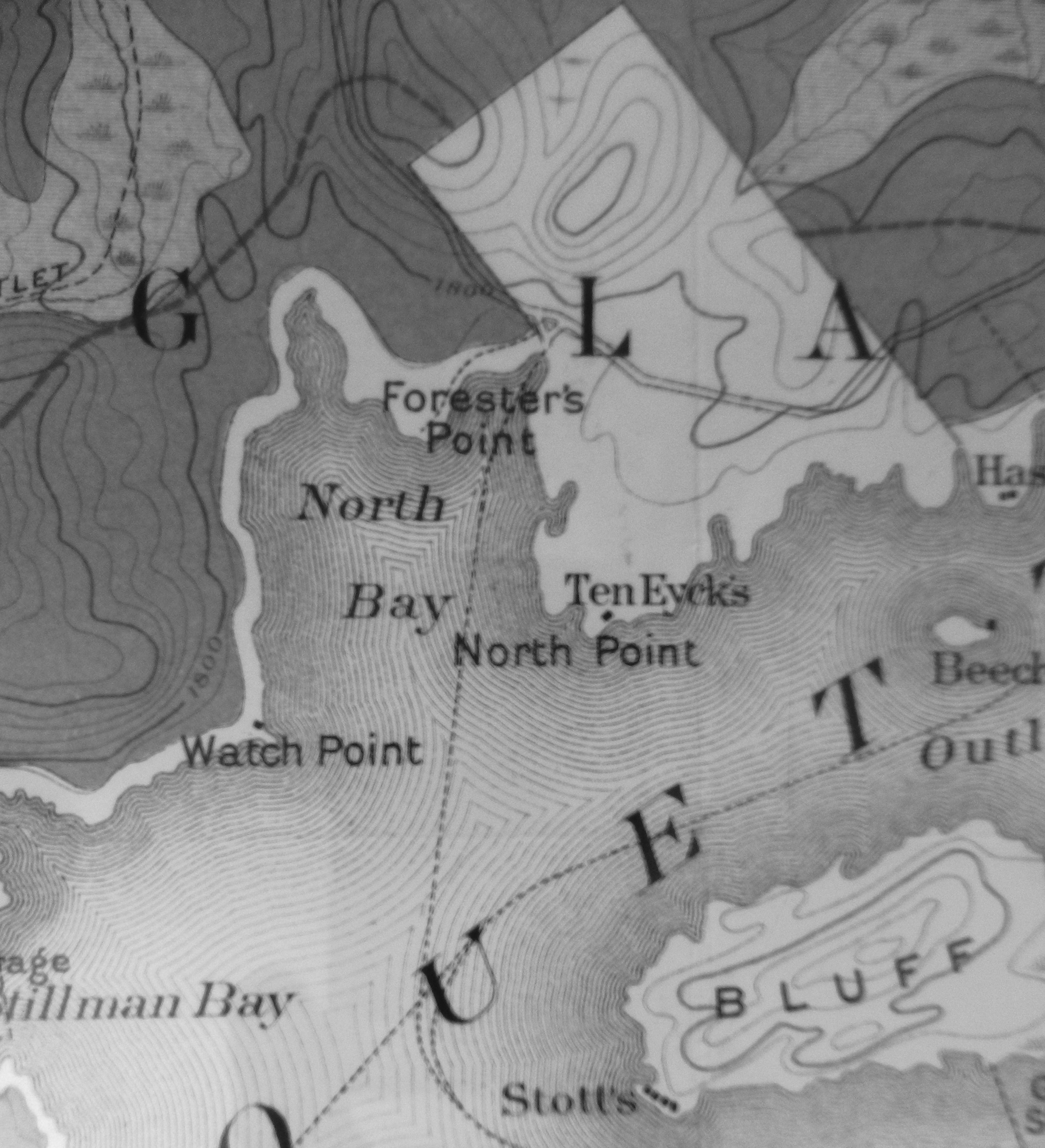
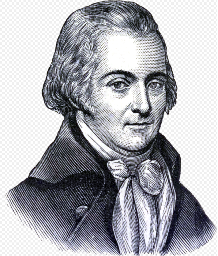
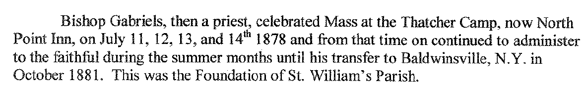
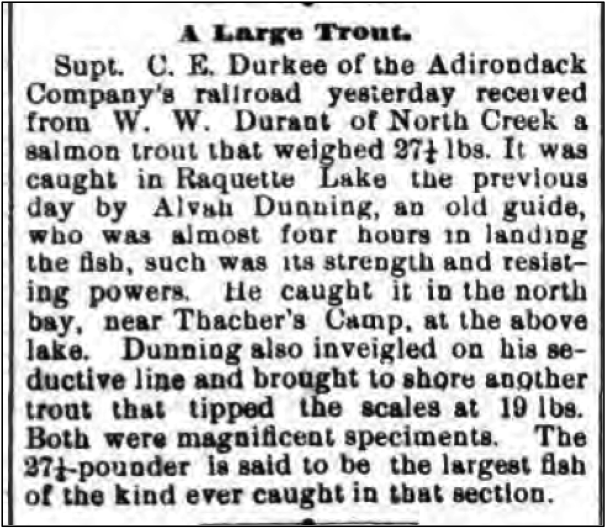
The legend of Sir John Johnson’s role in naming Raquette Lake has been written and re-written for more than a century.   Below is the earliest source I have found, from the 1891 New York State Forest Commission Annual Report. 1

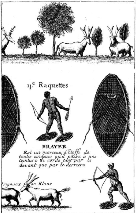
Its name is founded on a bit of history, hitherto traditional. During the War of the Revolution, a party of Indians and British soldiers, under command of Sir John Johnson…passed through the wilderness on their way from the Mohawk Valley to Canada. It was in the winter time, and, on reaching this lake, the party was overtaken by a sudden thaw, which made further travel on snow-shoes impossible. As the Indians and soldiers did not want to carry their snow-shoes, or raquettes, as they termed them, they piled them up and covered them over, making a large heap that remained there many years. The expedition had reached the South Inlet when the thaw set in, and it was there, on a point of land, that the pile was made… Old Mr. Woods, the pioneer settler of Raquette Lake, heard this story from the Indians themselves, and often pointed out to hunters the decaying fragments of the raquettes.

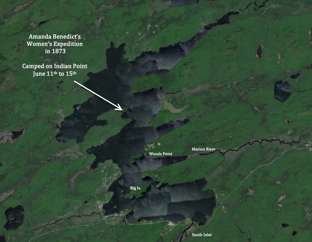
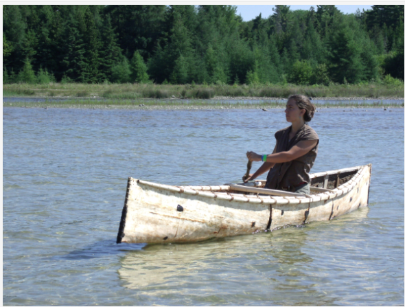
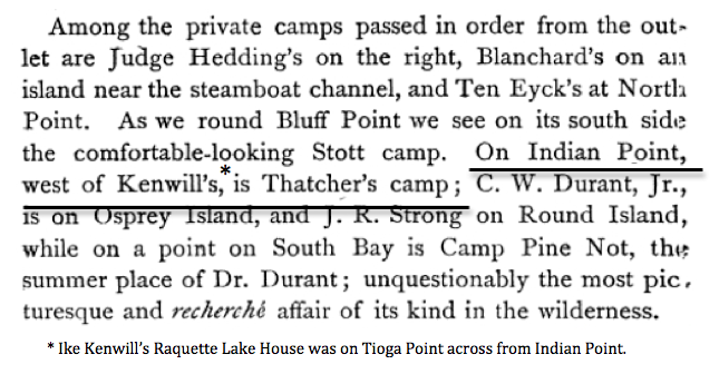
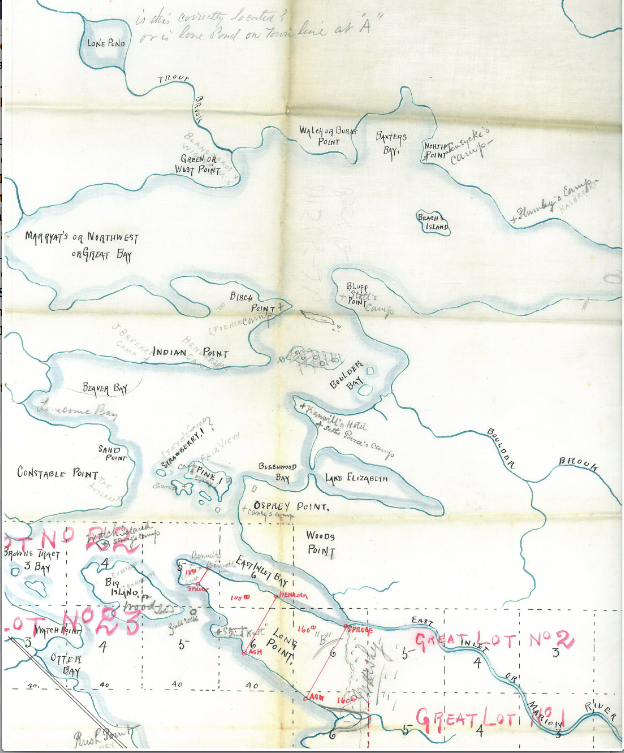
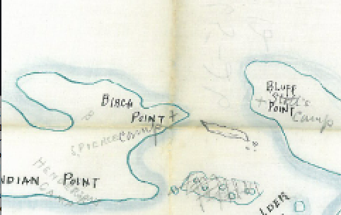
Believing that “Old Mr. Woods” refers to William Wood, I was intrigued to unravel the mysteries of this folklore. Wood was known to be close friends with local Indians, and the passage continues with a reference to Woods “in company with ‘Honest John Plumley’, Murray’s celebrated guide”. Wood sold his land on Indian Point to Plumley in 1859. 2

This folklore makes for a wonderful story, but two doubts are raised.

1) The passage infers that Wood saw the decaying fragments of the raquettes as late as the 1850s, about 75 years after being discarded. How would these fragments have survived so long?

2) Sir John Johnson actually fled Johnstown in late May, not “in the winter time”.   Why would snowshoes have been necessary?

raquettes

Unraveling possible answers to these questions has led me to propose a new theory regarding the timeline and method of Sir John Johnson’s escape.

Nowadays, the ice-out has never been later than the first week of May, and snow cover is gone from the woods by then. However, from 1550 to 1850 a period of significant cooling, termed the Little Ice Age, occurred with three particularly cold intervals, one during the American Revolution. In David Ludlum’s Early American Winters 1604-1820, weather records reveal five Northeast snowstorms occurred in May or June between 1773 and 1777, suggesting that snowshoes in late May is not a literary exaggeration. 3

Exaggerations of other details of Johnson’s escape are quite common, however.   The description offered by William Stone in his 1838 book The Life of Joseph Brant-Thayendanegea has been repeated so often as to take on the air of fact. 4

After nineteen days of severe hardship, the Baronet [Johnson] and his partisans arrived at Montreal in a pitiable condition – having encountered all of suffering that it seemed possible for a man to endure.

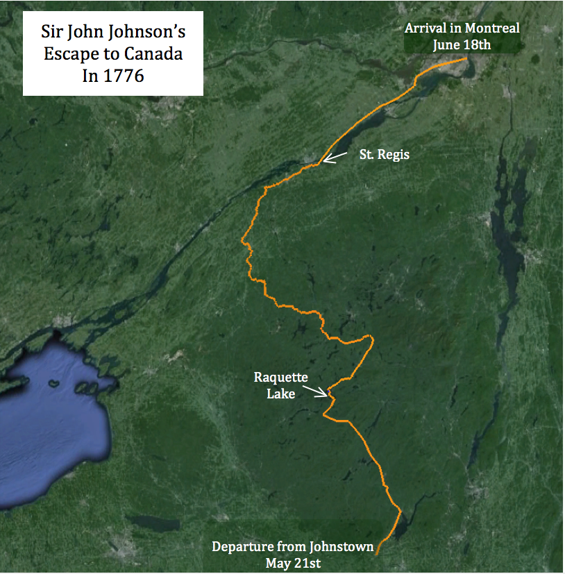
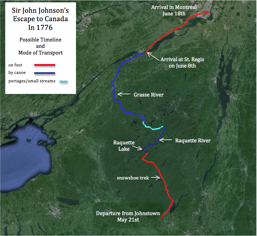
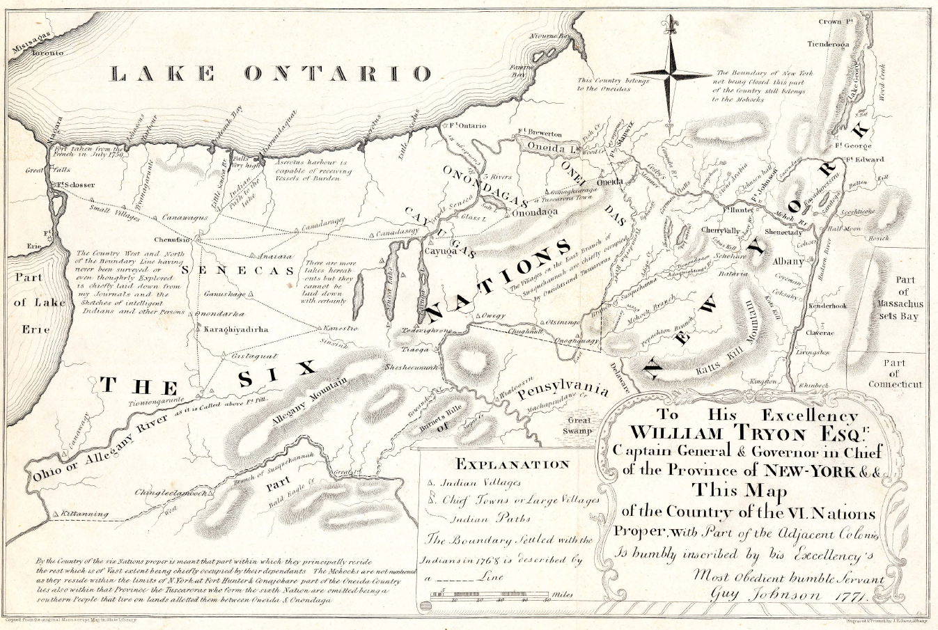
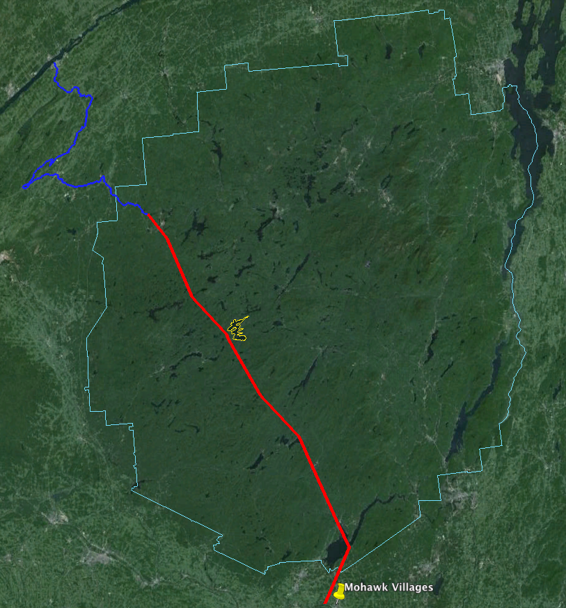
This notion that Johnson’s trek to Montreal took only nineteen days does not hold up under scrutiny, and Stone offers no citation.  Johnson did not keep a military diary of these days in the woods.   Historians have not found any primary sources written during the actual escape. Various historians have, however, pieced together the presumed route that Johnson took. The most accepted path is one proposed by J. Yates Van Antwerp, Johnstown Historian, in 1937. 5

According to Van Antwerp, Johnson’s party headed northeast from Johnstown to his family’s summer home, the Fish House on the Sacandaga River, then northwest along the river, passing north of Lake Pleasant and through the West Canada Lakes region to Raquette Lake.   They then followed the Raquette River to Long Lake. North of Long Lake they turned northwest, crossing over to the source of the South Branch of the Grasse River, which led to the St. Lawrence and on to Montreal.   The total distance is approximately 300 miles.   A 19 day trip would mean they averaged almost 16 miles a day. This is highly improbable.

The Continental Army averaged such a pace on the Washington-Rochambeau march from Dobbs Ferry, NY, to Yorktown, VA, in the summer and fall of 1781.  6  Johnson’s party snowshoeing narrow Indian trails and bushwhacking in sections could not have matched an army moving with horses and wagons over open roads.

While there are no primary sources from the escape, there are contemporary letters that shed light on the possible reason for Stone’s 19 day estimate. The only direct information of the escape comes from a letter written by Sir John Johnson to his brother on January 20, 1777.  

Upon my arrival at St. Regis with my party consisting of one hundred and seventy men who were almost starved and wore out for want of provisions, being nine days without anything to subsist upon but wild Onions, Roots and the leaves of Beech Trees [A], I was received in the most friendly manner by the Indians who informed me that the rebells were still in possession of La Chine and Montreal… I proposed to them to go off immediately and attack the former Post. They seemed very hearty, and desired that I would send to Capt. Forster at Oswegatche [Ogdensburg], for two field pieces, which had they had taken at the Cedres, which I did and in a short time received one of the field pieces with a Sergeant, one Artillery Man and three Volunteers, with which I set out after many delays [B]… I was joined by the Indians of the Lake of two Mountains, with many Canadians, but upon my arrival on the Island of Montreal, I was informed that the Rebells had abandoned both places the day before, and that the 29th Regt. had taken possession of Montreal. [C]

This portion of the letter reveals many details of Sir John Johnson’s timeline. The British had retaken possession of Montreal on June 17th [C], so Johnson arrived in the city on June 18th. 8

Three letters serve to identify May 21st as the date of his flight from Johnstown. 9

  • On May 18th, Johnson wrote a letter from Johnson Hall to General Philip Schuyler of the Continental Army in Albany.
  • On May 19th, Col. Dayton arrived at Johnson Hall to arrest Johnson on the orders of Gen. Schuyler and found Johnson had fled into the nearby woods.
  • On Wednesday, May 22nd, Dayton wrote “Sir John, with upwards of three hundred persons, several of whom are said to be armed, attempted on Tuesday morning to make his escape through the woods to Canada.”

Therefore we know for certain that the entire trip from Johnstown to Montreal actually took 29 days. (May 21 – June 18)

SJJ full route

If we work backwards from June 18th, we can estimate when he probably arrived in St. Regis, about 67 miles south of Montreal. Marching with a field piece on open roads to Montreal would have taken a minimum of four days. So the earliest Johnson could have departed St. Regis would have been June 14th.

Prior to departing St. Regis, Johnson had to regain strength from his ordeal in the woods and wait for the arrival of the field piece from Ogdensburg. It is difficult to know how long Johnson stayed in St. Regis. The request for and delivery of the field piece from 45 miles away in Ogdensburg [C] would have taken at least four days. Johnson says he “set out after many delays” after the arrival of the field piece.

If his time in St. Regis had stretched to six days, then the end of his arduous ordeal through the Adirondacks and his salvation among his Indian friends would have come on June 8th, nineteen days after departing Johnstown – perhaps the true origin of Stone’s 1838 account.

Even if we accept that the trek from Johnstown to St. Regis took 19 days, we still know very little about the trip itself. How many miles per day could Johnson’s party have advanced through the snow-covered forests between Johnstown and Raquette Lake? One proxy comes from the details on Adirondack Forum of a through-hike by snowshoe of the Northville-Lake Placid trail in the winter of 2006-2007. The group on that expedition averaged five miles per day.  10   At only five miles per day, it would have taken Johnson 14 days to reach Raquette Lake, requiring them to travel over thirty miles on each of the remaining five days to reach St. Regis.

Of course, the NLP through-hikers were not in fear of a pursuing army. Snowshoe trekkers advise an average of one mile per hour when planning a winter hike.  11  If we assume Johnson’s men pushed themselves ten hours per day, at that pace the time is shortened to seven days. Even so, they then would have had to maintain a pace of over thirteen miles per day from Raquette Lake to St. Regis. While snow cover and snowshoes no longer slowed them, we also know that in the last nine days they were subsisting on wild onions, roots and leaves. [A] Could they have maintained this significantly increased pace as their strength was failing them and the spring thaw yielded to mud season?

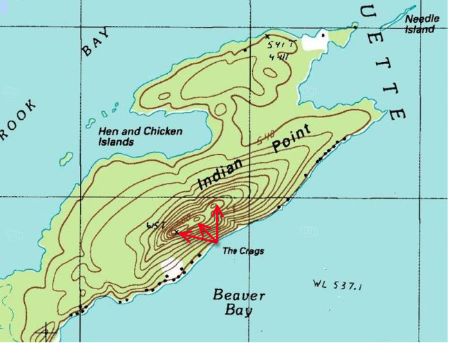
If Johnson intended to complete the trek on foot, why did he not follow the long established Mohawk trail which passes to the west of Raquette Lake and leads to the source of the Oswegatchie River? (see Why Indian Point?)

If Johnson’s party were seeking to avoid discovery, why would they create a pile of snowshoes on a prominent point upon the shores of Raquette Lake as opposed to hiding the pile further back in the forest?

What follows is pure conjecture that cannot be proven but does provide answers to these questions while not contradicting any known facts.   While he may have originally intended to march to Montreal, I believe during the hazardous trek to Raquette Lake, Johnson realized it would not be possible. I think he sent word to St. Regis to send a group of Mohawks to aid his escape.

The Iroquois were noted for their use of relay runners who collectively communicated messages over eighty miles in a day.  12  According to William Stone in The Life of Joseph Brant-Thayendanegea, Brant claimed that Mohawks were sent south from St. Regis to aid in Johnson’s escape.  13   Sue Herne of the Akwesasne Museum of the St. Regis Reservation says that today’s Mohawk oral history corroborates this story.  14

Just as Johnson appears to have communicated northward, it would appear that he intentionally created a campaign of misinformation to throw the Continental Army off his track. Col. Dayton believed Johnson was traveling west to Niagara via Oneida Lake. He based this on comments from Sir John Johnson’s wife and testimony of an Oneida Indian on May 23rd who claimed a flotilla of bateau boats were awaiting Johnson at Oneida Lake. He also received intelligence that a road had recently been marked from Johnson Hall to Fort Brewington on Oneida Lake. 15

I believe Mohawk runners could also have brought the news to Johnson that Gen. Schuyler’s scouts had reported finding no trace of them and claimed that the trail to the north was impassible.  16  This would have allowed Johnson time to alter his plan.

Johnson already had three Mohawks guiding his men north when they left Johnstown.  17   However, Van Antwerp’s account speaks of 25 Mohawks aiding the escape.  18  I believe the additional Mohawks were sent south from St. Regis to construct elm bark canoes at Raquette Lake so Johnson could continue his escape by water. Switching to water transport here rather than continuing on the familiar Mohawk trail to the Oswegatchie River, Johnson saved his party another thirty miles of arduous hiking through the forest.

canoe_bark1825

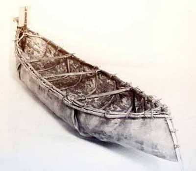
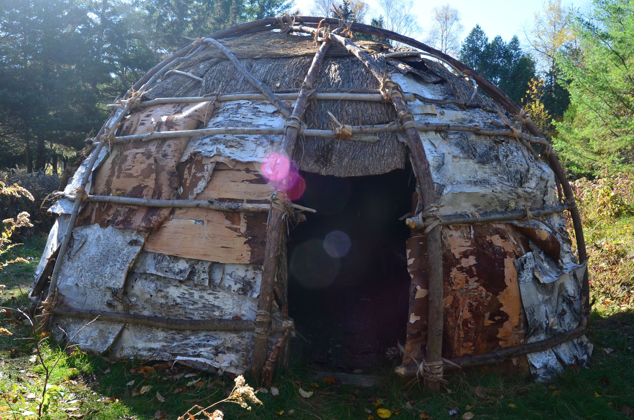
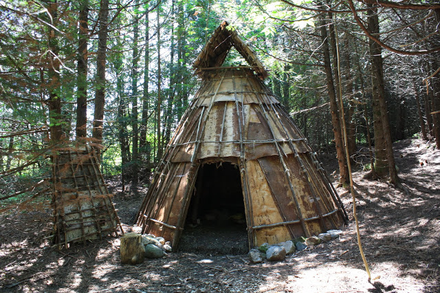
The Iroquois were known to primarily use elm bark canoes. In contrast with birch bark canoes, an elm bark canoe could be built in as little as two days. The process is similar to building a spruce bark canoe (see Mitchell Sabattis-Boatbuilder). Given the cold weather during Johnson’s escape, it was likely necessary to use boiling water to strip the bark from the trees. This slower process might have stretched the construction time to four days.  19

The travel times of the Iroquois using elm bark canoes on various water routes in 1656-1657 are detailed in early records of Jesuit missionaries, which indicate the Iroquois travelled an average of 45 miles per day downstream and 20 upstream. 20

I estimate that Johnson’s party could have travelled 20 miles per day from Raquette Lake through Long Lake and the small streams and portages to the source of the Grasse River, covering this distance in approximately three days. Given their weakened physical condition, I will conservatively estimate a pace of only 35 miles per day paddling downstream on the Grasse River, arriving at St. Regis in another three days.

SJJ Possible Route

Therefore, by water and portages the Johnson party could have made it from Raquette Lake to St. Regis in six days. This leaves thirteen days between fleeing Johnstown and when they departed from Raquette Lake. If four days were devoted to building the canoes, a snowshoe trek pace of only eight miles per day would have been sufficient to reach Raquette Lake in nine days.

I believe the pile of snowshoes was placed on the lakeshore because that is where they departed in the elm bark canoes.   The pile was covered up by the waste from the canoes’ construction. After 75 years of decomposition of this waste layer, the remnants of the snowshoes were still visible to William Wood.

END NOTES


Suffering Fools

I am entering a phase where I have to once again spend significant time researching new stories about these fifty acres.   For that reason, I am going back to publishing completely new stories only once a month.  Interspersed between those original works I am going to republish excerpts from the stories of Adirondack writers from the 19th Century.   From the tale of L.E. Chittenden’s 1846 travels with Mitchell Sabattis and some unfortunate traveling companions, I bring you a portion of Adirondack Days – Untried Companions in the Wilderness – Their Perils and Experiences.

1

Click this page to be linked to the online version of this entire book.

Screen Shot 2014-11-08 at 5.38.32 AM

3

4

5

6

7

8

9

Mitchell Sabattis – Boatbuilder

When I walk the land around Matthew Beach’s original hut and William Wood’s shanty, I imagine the Abenaki Indian guide Mitchell Sabattis pulling into their landings in a canoe or guideboat made by his own hand. Indian Point was a waypoint for many a traveler boating through the Central Adirondacks.

Screen Shot 2014-10-20 at 9.17.23 PM

1890 Engraving of a photo of Sabattis by Seneca Ray Stoddard

While it is impossible to know how often Sabattis visited these acres, we have written record of at least 3 occasions: his trips with Joel Tyler Headley in 1844-46, accompanying C. W. Webber in 1849, and an expedition of women who explored the region in 1873 (beautifully told in Barbara McMartin’s book To the Lake of the Skies)

Sabattis guided for my great-great-grandfather George Hornell Thacher in 1862 as they explored the region from a base camp Sabattis had on Crane Point on Blue Mountain Lake. However, even if Thacher travelled to Raquette Lake as early as 1862, it is unlikely that he spent a night on Indian Point.  Sabattis maintained a campsite from 1852 to 1877 on Watch Point according to Ken Hawks, who now owns the property.

A member of the St. Francis tribe of Abenaki Indians, Mitchell Sabattis was born in Parishville, St. Lawrence County in 1823. He began to accompany his father Captain Peter Sabattis on hunting expeditions at the age of seven.  At eleven, he was one of the earliest settlers in Long Lake, moving there with his father in the early 1830’s. Over a life of 83 years, he and his wife Elizabeth raised five sons and a daughter. He was a founding member of the Wesleyan Methodist Church of Long Lake. In 1865, he raised funds to build the church where he frequently played the violin, sang and preached.  When not working as a guide he tended to a 20-acre farm on his 160-acre homestead.

Screen Shot 2014-10-20 at 9.20.03 PM

Image of Sabattis on Long Lake near Sagamore Hotel in 1886 – History of the Adirondacks. A. Donaldson. 1921.

Much has been written about Sabattis as the legendary Adirondack Guide, but I am intrigued by his abilities as a boat builder. The historian Alfred Donaldson claimed that Sabattis created the first guide boat around 1849.   Subsequent historians have debated different people as the originator of the idea for the guideboat’s design. Nonetheless, Hallie Bond says in Boats and Boating in the Adirondacks, “The guideboat did not spring full-blown from the forehead of Mitchell Sabattis, or anyone else for that matter, but Sabattis, living in the center of early guideboat development, may well have had a hand in its evolution.”

The earliest tale of Sabattis describes his skill in building another type of boat – a spruce bark canoe like the one shown here.

In 1843, John MacMullen and his friend Jim R. were rescued along the Raquette River by Mitchell Sabattis, who was travelling with two men (one is presumed to have been his father Peter), two women and a baby.   For one day all eight crammed into Sabattis’ birch bark canoe, which barely stayed afloat with the water only three inches below the gunwales. Upon reaching a cabin on the shores of Tupper Lake, Sabattis decided to construct a spruce bark canoe to carry four of the men. MacMullen described the process in The Evening Post of New York in 1880:

This kind of craft is made of a single piece of bark while a birch canoe is made of many pieces fastened together. The process of making our canoe was very interesting. A fine large spruce tree about a foot and a half in diameter was chosen that grew in an open space near the river and had fifteen feet of good thick bark without break or knot-hole. The tree was cut down, [they] relieved one another in the work, a ring was cut through the bark along the trunk. ‘Spuds’ were made, and the whole clear sheet of bark, fifteen feet long and four feet wide, was laid upon the ground with the inner side down.

[Captain Peter Sabattis] then cut away a slender triangular piece of the thick outer bark, about six inches at the base and about three feet from each end, leaving the flexible inner bark to fold over so that when the corners were brought together and the ends closed up the bow and stern might both be somewhat higher out of the water, and the sides need not sag out so much in the middle.

The ends of our boat were sewed up with the roots of the spruce tree. These slender roots or rootlets can be had of six feet in length and running from a quarter of an inch down to a point. The smaller part is taken to use as thread. A hole is made in the bark with a sharp stick and the rootlet thus inserted… The spruce gum is used to make the inside of the seam water-tight. Thus this tree supplied for our boat bark, thread and gum…

Long, narrow pieces of cedar… fifteen feet long by two inches wide, and only three quarters of an inch thick, [were] split almost as smoothly as if they had been sawed. These pieces were used as gunwales and tied on with strips of tough and flexible bark passed through punched holes. Strips of wood thin enough to bend were cut just of the proper length and then forced in so that they followed the curve of the boat, their strong crosspieces also ran athwart between the gunwales to stiffen the craft…This ‘naval construction’ took the best part of two days.”

Discussing the origins of the Adirondack guideboat, John Duquette wrote in the Adirondack Daily Enterprise: “To avoid the solid weight of a skiff or dory, it was necessary to experiment with a skeletal frame sheathed with light but strong material. The frame consisted of a bottom board with ribs that were bent or steamed to fit an outer shell. Ribs that were bent had a tendency to warp which resulted in a distortion of the hull. An alert Adirondacker noticed that an uprooted spruce tree disclosed a natural crook where the root grew out from the base of the tree. Here was a strong resilient piece of wood in a shape that required no bending.”

While a spruce bark canoe does not use solid pieces of spruce root wood for ribbing, Sabattis would have been keenly aware of this unique attribute of the spruce tree’s roots. He is as likely a candidate as any other to be the one who contributed this innovation to the design of the Adirondack guideboat.

(watch a video of the recent construction of a spruce bark canoe https://www.youtube.com/watch?v=u6V-v7mVymo )

Searching for the 1878 Thacher Cabin on Indian Point

In my last piece regarding when the mysterious Thacher Cabin was built, I cited numerous newspaper articles and books that referenced the cabin’s existence.   However, none of them clarified where the cabin was built. Previously reviewed maps of Raquette Lake gave no indication and no photos or drawings of the cabin have been found.

I chose to begin my search by focusing on the one visitor to the cabin for whom historical records might exist.   In Aber and King’s History of Hamilton County, it is written that the priest Rev. Henry Gabriels performed Catholic Mass at the Thacher Camp from July 11th to the 14th in 1878. Gabriels later became the Bishop of Ogdensburg. In the hope that this early mass in the Adirondacks might be of historical significance, I contacted the archivist of the Diocese of Ogdensburg looking for any original documents or photos of Gabriels’ visit.

Imagine my surprise when the archivist sent me the following photocopy from notes that he found:

Gabriels North Point Inn

“North Point Inn”? Could I be wrong in my assumption that the 1878 cabin was built on our family’s land on Indian Point? The North Point Inn was located across North Bay from Indian Point. My mind raced as I retraced my steps looking at all of the newspaper articles and books.

One New York Times article had said “There’s ex-Mayor Thatcher of Albany’s place,’ said the Captain of the little steamer, pointing to a fine lodge on the north shore.”   Did he mean the north shore of Raquette Lake and not the north side of Indian Point?

I then realized that when Nessmuk wrote of visiting the cabin, he simply wrote “a gentleman by the name of Thatcher (sic) who has a fine residence on Raquette Lake.” No mention of Indian Point whatsoever, just my assumption.

Fortunately, my heart rate eventually was calmed, after a day of frantic research turned up this from Seneca Ray Stoddard’s 1880 edition of The Adirondacks Illustrated:

Screen Shot 2014-08-04 at 5.09.25 PM

Once again confident of the cabin’s existence on Indian Point, I now tried to discover where on the land it was situated. I began by reviewing the property deeds. In 1876, John Boyd Thacher purchased two parcels on the tips of Indian Point. He paid nine dollars an acre to Marshal Shedd for roughly 25 acres. This first parcel is all the land to the east of the yellow line shown below, except for the area to the east of the blue lines.   JBT paid twenty-two dollars per acre to a William W. Hill for this second parcel of only 4.5 acres.

William H Hill Parcel arial

Eureka! Why would JBT pay more than twice per acre for the second parcel? Could it be that it contained an existing cabin? Was this the location of what became known as the Thacher Camp?

Alas, let me just say that there exists another explanation as to why JBT paid a high price for the second parcel. As the deed indicated that William W. Hill was from Albany, I thought it best to see if there was any connection between Hill and the Thacher family. Perhaps a higher price was paid as a favor to a friend.

Indeed, I found that William W. Hill and John Boyd Thacher were 33 degree Freemasons and both members of the Albany Chapter of the Rose Croix.   William W. Hill was an amateur entomologist whose collection of over 10,000 specimens of butterflies and moths was donated to the New York State Museum. Hill was also an officer of the Albany Institute. JBT had much in common with Hill’s scientific and preservationist inclinations and I have no doubt in claiming them to be more than mere acquaintances.

This explanation does not completely eliminate the possibility that there was an existing cabin within Hill’s parcel.   However, an epiphany came to me that argues against George Hornell Thacher establishing his camp on the southern shore of Indian Point.

No fewer than five newspaper articles and Nessmuk’s book speak of George Hornell Thacher’s love of lake trout fishing. Anyone who knows Raquette Lake understands that in summer, one fishes for lake trout exclusively in North Bay, where the depth provides the cold water desired by the trout. It is logical that GHT would have built his cabin along the north shore of Indian Point.

Indeed, a fish tale would prove to be the conclusive clue. On July 10, 1879, the Weekly Saratogian published:

Alvah fish

So clearly the Thacher Cabin was somewhere along the north side of Indian Point, but where?

Early in my research, the Adirondack Museum Librarian Jerry Pepper had shown me a hand-drawn map of Raquette Lake.  The museum did not know who created the map or when it was created.

Raquette 1881-1882 map cropped

The map has an X marked next to the word “Camp”, written in cursive, on the end of Birch Point.

Raquette 1881-1882 map close up


As this is the location of our family’s little, red one room cabin built in 1910, I assumed at first that this map was from the early nineteen teens.   However, further analysis revealed a different conclusion.

In addition to the geographic locations marked in ink, the map has the names of various camps written in pencil along the shore. There are two distinct sets of handwritten notations, one in cursive and one in block letters.   Based on the time period in which each of the named landmarks existed, the cursive notations predate those in block letters. The comparison of the dates reveals that the notation for the “Camp” on Birch Point reflects the year 1881 or 1882.

It would appear that the first Thacher Cabin was built in 1878 very near if not actually on the same ground where our little red cabin still stands today. What I would give for any photos that show the tip of Birch Point, even in the background, taken between 1878 and 1885.


Why Indian Point?

6 Indian Point red yellow and cabin

Matthew Beach and William Wood settled on the lands to the east of the red line. John Boyd Thacher purchased the portion to the east of the yellow line. The small red dot is the location of the little red cabin built in 1910.

Echoing across time, this question can be asked three ways.  Who were the Indians of its namesake?  Why did Matthew Beach and William Wood choose it for their home? Why was John Boyd Thacher enticed to buy these acres?

According to local lore, Indian Point was the site of an Indian settlement.  The earliest such reference was made by Joel Tyler Headley in The Adirondack: or Life in the Woods, published in 1849.

Screen Shot 2014-01-28 at 8.52.39 PM

Most research does not support the idea of large, permanent  Native American settlements within the Adirondacks.   However, evidence points to the Adirondacks being used as a seasonal hunting ground for the Iroquois, Huron and Algonquin Indians.  Four clues point to the area of Raquette Lake being under the control of the Mohawk Nation of the Iroquois Confederacy or Ho-dé-no-sau-nee (People of the Long House).  This map of the Six Nations of the Iroquois shows the Mohawks’ territory beginning to the west of Raquette Lake and expanding east to Lake Champlain. (Enlarge the map by clicking on it and read the text to the right of the compass rose)

Screen Shot 2014-01-26 at 2.28.39 PM

Guy Johnson’s 1771 Map of the Country of the VI Nations. New York State Museum.

Another clue is that the lands which would become the Totten & Crossfield Purchase (which includes Raquette Lake) were originally purchased by the British Crown from the Mohawk Nation in 1771.   The British had purchased the lands from the Mohawks for 1,000 pounds and sold it to Totten & Crossfield for 40,000 pounds in the same year.  (And you thought flipping real estate was a modern invention!)   Although this land sale took place, the Mohawk Nation later continued to claim the lands and use them until a peace treaty between the newly formed United States and the Iroquois was signed in 1794. 2

In Adirondack Pilgrimage, Paul Jamieson makes the argument that the Albany Road (sometimes referred to as the Old Military Road) constructed for the War of 1812 actually followed the path of an Iroquois trail which dates back to the 1600s.  Jamieson mines the first person writing of a Jesuit Priest named Joseph Poncet who was captured by Mohawks in 1653.  Poncet’s description combined with Jamieson’s research and that of Stephen B. Sulavik in Adirondack: Of Indians and Mountains 1535-1838 yields my approximation of the heavily travelled Mohawk trail which passed just to the west of Raquette Lake, traveling from the Mohawk River Valley to Canada.   The foot path led through the forest to the Oswegatchie River by which the Indians canoed to the St. Lawrence River.

Screen Shot 2014-01-26 at 4.32.19 PM

Beyond the evidence of this Mohawk trail passing close to Raquette Lake, the only other history which directly connects the Mohawk Indians with the lake is the escape of the Tory Sir John Johnson from Johnstown to Montreal in 1776.   His Mohawk guides brought him through the woods to the shores of Raquette Lake and then by canoe north to Canada, a tale which will be retold in a future chapter.

This scant evidence implies that the Mohawks were well acquainted with Raquette Lake for over a century.  But did they have an encampment on Indian Point?  There are no contemporary written histories which specifically speak of the use of Indian Point by the Mohawks.  My conjecture is based on descriptions of how large hunting parties of Mohawks would travel from their year-round villages along the Mohawk River to encampments in the Adirondacks from November to late January.

Father Isaac Jogues is another French Jesuit priest who was captured by the Mohawks in 1642, and his writings describe a hunting expedition departing from the Mohawk village of Ossernenon along the Mohawk River:

If we can assume that such a winter hunting camp existed on Indian Point, why did the Mohawks choose this location along the almost one hundred mile shoreline of Raquette Lake?  I believe it is the geography and topography which influenced their choice.

According to Lewis Morgan in the League of the Ho-De-Nau-Sau-Ne or Iroquois, “For three quarters of a century, from the year 1625 to the year 1700, the Iroquois were involved in almost uninterrupted warfare [with other Indian nations]…from about the year 1640 to the year 1700, a constant warfare was maintained between the Iroquois and the French.”  The 18th century brought ever greater conflict between the Mohawks and Europeans over control of Adirondack territory for the lucrative beaver fur trade. 3

In this context, the Mohawks would have benefited from siting their winter hunting camp in a location on Raquette Lake which could be defended and from which they could observe any approaching enemies.  Indian Point possesses a unique geological feature called the Crags, a series of three rock outcroppings at the top of the ridge line on the peninsula.  At an elevation of 2000 feet, even today one can see all the way to South Inlet, and anyone approaching from the Marion River or Brown’s Tract Inlet would be seen at least an hour before they could land on the shores of Indian Point.  To the northwest, one can see Sucker Brook Bay.

Screen Shot 2014-02-01 at 8.51.14 PM

USGS Raquette Lake Quadrangle Map

While today the tree cover does not provide a view to the northeast, images from the 1800s indicate that the Crags were almost clear of trees and it is highly likely that a lookout stationed there in the 1600s and 1700s would have also been able to see anyone rounding Bluff Point to the northeast of Indian Point.

Drawing from Craggs

Looking South from the Crags – a wood cut printed in Wallace’s Descriptive Guide to the Adirondacks. 1872.

Seneca Photo from Craggs

Photo from the Crags by Seneca Ray Stoddard. circa 1880.

While the Crags may have led the Mohawks to choose Indian Point, where along the shores of the peninsula was the hunting camp?  As the camp would have been used mostly from November to late January, I suspect a location sheltered from the worst of the cold winds blowing across Beaver Bay or North Bay.   Either of the two protective coves would have served well, the cove near Hen and Chickens Islands or the little bay between the two points on the eastern tip.

An understanding of the size and description of a hunting camp helps to create a theory as to where on the peninsula it was located.  Father Jogues’ description implies that a family clan headed by a Chief would likely all relocate to the winter hunting grounds.  The villages in the Mohawk River Valley  would each have several Long Houses.  Each Long House would be the home of a family clan.   The length of the Long House and the number of fire pits within the Long House would relate to the number of families.  An account of Dutch explorers encountering a Mohawk village in 1644 described one Long House of eighty paces in length being home to a Chief, 40 men and 17 women. 4

The Mohawks’ method of hunting deer illustrates the need for a very large hunting party.  Father Jogues experienced the hunt firsthand, “They beat up the stags and the elks from their coverts, and drove them headlong toward the fences that strecthed between the trees and into the narrowing alleys of the traps, were they could easily be slaughtered.  They tracked the animals over the rise and fall of the mountains, and had the zest of dropping them with musket or arrow or javelin.”

Morgan in League of the Ho-De-Nau-Sau-Ne or Iroquois, provides an even more detailed description of the hunting method:

The construction of a V-shaped fence that stretched two to three miles on a side would have required significant manpower.  If the Indian “settlement” on Indian Point was a winter hunting camp, it likely was the temporary home to at least fifty or more people.

A young Mohawk woman named Kateri Tekawitha described one style of temporary shelter used in a winter hunting camp in the late 1600s.

This depiction has been faithfully recreated by Barry Keegan, an expert in primitive Native American structures, in his construction of a traditional wigwam on the shores of Prospect Point on Blue Mountain Lake.

1415364_10201061516442946_2004213794_o

A traditional wigwam hunting-lodge constructed at Prospect Point on Blue Mountain Lake by Barry Keegan. Photo by Jerry Krasnick.

According to Keegan,  “South of the Adirondacks, wigwams were usually dome shaped and often sided with elm bark; north of our region they tended to be conical, like squat-shaped tepees with birch bark as the siding of choice. The Adirondacks are right on the border between those two types and probably both were in use here, at the very least as seasonal hunting camps.” 5

Father Jogues’s writings appear to describe the second style, “There the [women], under the direction of the men, threw up the three slanting poles of the hunting-huts and tied them at the top and sewed the bark and skins firmly about the triangular frame.”

IMG_0344

A conical teepee style hunting lodge from creaturehomes.blogspot.com

The “hunting-lodges of bark and close-woven boughs” referred to by Kateri or the bark tee pee style described by Jogues appear to have housed a small family of five to ten people.   To accommodate upwards of fifty to one hundred people, the winter hunting camp on Indian Point would have required up to ten lodges.  The annual construction of these lodges for over a century would have established significant forest clearings on Indian Point.

My theory that the hunting camp was on the shores of the little bay nestled within the eastern tips of Indian Point is tied to the reason I believe Matthew Beach and William Wood chose to settle at that spot.  My theory echoes one regarding land use in the Adirondacks first promoted in the late 1800s in an article in the New York Times.

Screen Shot 2014-02-02 at 6.27.40 PM

“The North Woods of Old” The New York Times. May 11, 1890.

The site of the Mohawk hunting camp would not have been open land by the 1840s. The majority of the Mohawk Nation relocated to the St. Lawrence River Valley on both sides of the New York/Canadian border after the Peace Treaty of Canandaigua in 1794 between the Iroquois Confederacy of the Six Nations and the new government of the United States. 6   Although Mohawks continued to come down from Canada into the Adirondacks for hunting in the early 1800s, it is likely that secondary forest regeneration began to take hold of the area of the hunting camp on Indian Point.

Beach and Wood were not simply hunters and trappers.  They also cleared ten acres of cropland to grow potatoes and vegetables.  When they first travelled the shores of Raquette Lake in search of where to stake their claim, Beach was nearly sixty years old and Wood was in his early forties.  I am sure they had a strength and vigor beyond what this author is capable of at 46, and they were accustomed to hard physical work.  Nonetheless, knowing that they intended to clear the land for farming, an area previously cleared by over a century of indigenous use yielding a young secondary forest would have been easier for Beach and Wood to clear with fire and axe than the surrounding primary forest of large diameter trees with deep rooted trunks.

young secondary forest

Young secondary forest

Old growth primary forest

Old growth primary forest

Screen Shot 2014-02-03 at 10.12.44 PM

Beach and Wood chose the twin tips of Indian Point because of the land use potential derived from the remains of the Mohawk hunting camp.  Conversely, the purchase of this land by John Boyd Thacher is puzzling in that it appears that he never really used the land.  It was his father George Hornell Thacher who built and frequented the mysterious original cabin, and yet the title to the land was always only in JBT’s name.  Could it be that JBT was motivated to buy the lands for their historical value?

JBT was an industrialist and politician but also an historian and scholar.  He was a renowned authority on Christopher Columbus and a collector of over 5,000 books and manuscripts from the 15th century, which his widow donated to the Library of Congress.  Among his varied interests, he showed a keen appreciation for the Iroquois Confederacy.  His collection included the original 1630 signed contract between the Iroquois and the Dutch for the sale of the land upon which the city of Albany was built.   At Albany’s Bicentennial Celebration in 1886, then Mayor JBT gave an eloquent speech welcoming a delegation from the Caughnawaga tribe and honoring the Iroquois Confederacy as the blueprint for our democratic form of government. 8

In 1893, he purchased four historically important Iroquois wampum belts. 9   The Hiawatha Wampum Belt was created in the 1500s to commemorate the union of the Five Nations of the Mohawks, Oneidas, Onondagas, Cayugas, and Senecas into the Ho-dé-no-sau-nee or Iroquois Confederacy.  To the Iroquois, this wampum belt is equivalent to the original copy of the Constitution of the United States.

Screen Shot 2014-02-02 at 9.04.41 PM

Hiawatha Wampum Belt

The George Washington Wampum Belt commemorates the Treaty of Canandaigua of 1794 which brought peace between the newly formed United State of America and the Iroquois Confederacy.

Screen Shot 2014-02-02 at 8.24.24 PM

George Washington Wampum Belt

The other two wampum belts commemorated the first encounter between the Iroquois and European explorers in the 1500s and their encounter with Samuel Champlain in 1609.

Given John Boyd Thacher’s clear respect and appreciation for the culture of the Iroquois Confederacy in his later years, I do not think it unlikely that as a young man of thirty he would be attracted by the folklore of an “Indian settlement” that once graced the tips of Indian Point.

Nessmuk Comes to Visit

Nessmuck Woodcraft p63

Published on page 63 of Woodcraft by Nessmuk in 1884.

Whenever and wherever the original Thacher cabin was built on Indian Point is my holy grail.  Delving into the details of the few literary mentions of the cabin might yield clues.  This visit by Nessmuk was published in 1884; however, it makes no mention of when the encounter actually occurred.  I needed to learn about this man called Nessmuk.

Screen Shot 2013-12-14 at 11.50.52 AM

Title Page of Woodcraft. George Washington Sears. 1884.

Nessmuk was the pen name of George Washington Sears.  In his youth, he had been befriended by a young Narragansett Indian named Nessmuk (“wood drake”) who taught him hunting, fishing, and camping.  Later he took the Indian name for his pen name and its English translation for the name of his first canoe.   His book Woodcraft was first published in 1884 and remains in print today as one of the most widely read guides for the bushcraft and wilderness survival community.

According to the editor Dan Brenan in The Adirondack Letters of George Washington Sears, “At the age of 59, a little more than 5 feet tall, weighing less than 105 pounds, and weak with acute pulmonary tuberculosis, Sears decided to see if the Adirondack lakes and forests could improve his health. Since Sears was so small and weak, he could not carry the usual heavy guide boat over the carries between the lakes of the Fulton Chain. He persuaded J. Henry Rushton to build him solo canoes that he could carry.”

Nessmuk published accounts of his three trips through the lakes and streams of the Adirondacks  in a series of letters to Forest and Stream magazine: “Cruise of the Wood Drake” (1881), “Cruise of the Susan Nipper” (1882), and “Cruise of the Sairy Gamp” (1883).     

The high regard and esteem in which Nessmuk was held by his readers is evident in the editorial published by Forest and Stream to promote the creation of a memorial for him.

Screen Shot 2013-12-14 at 2.07.27 PM

Forest and Stream. February 9, 1893.

Nessmuk photo

George Washington Sears – “Nessmuk”


So when did this renowned writer meet my great-great-grandfather George Hornell Thacher at his “fine residence” on Raquette Lake? Three clues appear to reveal a possible date.

Nessmuk’s habit appears to have been to write not about what transpired on the day he put pen to paper, but about his adventures in the preceding days.  This combined with the fact that often only the date of publication in Forest and Stream is known for most letters, makes it a challenge to date the actual occurrences of which he writes.

In a letter published on August 9, 1883, he describes his travels through the Fulton Chain prior to his arrival at Raquette Lake.  That letter does identify that it was written at Raquette Lake on July 27, 1883.  If one is to assume that Nessmuck would choose a day of idle and not a day of arduous paddling to compose his letters, it is likely that his letter of July 27th was written on the day he later described in his letter published on August 16th.

Screen Shot 2013-12-15 at 9.46.15 PM

Forest and Stream. August 16. 1883.

In a letter written while at Paul Smith’s and published August 23, 1883, Nessmuk tells of his visits to various private camps on Raquette Lake.

Screen Shot 2013-12-15 at 8.31.05 PM

Forest and Stream. August 23, 1883.

Notice the repetition of the text in bold within both letters.  I believe Nessmuk is describing the same day in two different letters.  Given that the Raquette House was directly across from the original Thacher Camp on Indian Point, I am fairly confident that the two men made their acquaintance on July 27, 1883.

The Sairy Gamp that carried Nessmuk to this rendezvous with my ancestor is described by Forest and Stream fisheries editor Fred Mather:

Nessboat

My Angling Friends. Fred Mather. 1901.

Screen Shot 2013-12-14 at 4.49.17 PM

The Sairy Gamp on display at the Adirondack Museum.

I can only imagine that this fateful visit might once have been the topic of an encounter between Fred Mather and John Boyd Thacher, GHT’s son.  Although no evidence exists to corroborate it, I suspect such an encounter did happen and would have been described like this in Forest and Stream,

Screen Shot 2013-12-16 at 5.20.21 AM

A fictional but historically accurate allusion to facts.

To entice you to seek out Nessmuk’s writings, I have reproduced one of his stories,

Screen Shot 2013-12-14 at 1.55.24 PM

Screen Shot 2013-12-14 at 1.55.46 PM

Screen Shot 2013-12-14 at 1.56.15 PM

Screen Shot 2013-12-14 at 1.56.34 PM

Enjoy one of his poems from his book of poetry Forest Runes published in 1887.

Screen Shot 2013-12-14 at 3.09.13 PM

Screen Shot 2013-12-14 at 3.09.41 PM

Screen Shot 2013-12-14 at 3.09.58 PM

Timeline

Events on these Fifty Acres of Beach and Wood

These points in time reveal some of the stories, of import and of good sport, that are yet to unfold in this blog.

1650-1794

Indian Point is used as a Winter hunting encampment by the Mohawk tribe.

1776  

The tory Sir John Johnson camps at Indian Point during his harrowing 19 day escape to Canada.

1837

At a pond northwest of Indian Point (Lone Pond or Cranberry Pond?), William Wood traps the last beaver seen alive in the Adirondacks until they were reintroduced in the beginning of the 20th century.

1837-40

Matthew Beach and William Wood became the first permanent settlers of Raquette Lake with their cabin built on Indian Point.  Exact date undetermined.

1840-43

Professor Ebenezer Emmons, first surveyor and the person to give the region the name “Adirondacks”, repeatedly stays with Beach and Wood while surveying the area.

1844-46

Joel Tyler Headley writes in his 1849 book The Adirondac – Life in the Woods of visits with Beach and Wood during his earlier explorations with guide Mitchell Sabattis.

1845

J.H. Young publishes the first map of New York State that shows a body of water in the location of Raquette Lake.  Only Long Lake to the north is named on the map and the drawing of Raquette Lake is almost completely inaccurate except for the detailed, near accurate depiction of Indian Point.

1849

Beach and Wood purchase from Farrand Benedict legal land titles giving them each an equal share of the 50 acres they have occupied on Indian Point.

1854

Beach deeds his 25 acres to Amos Hough of Long Lake contingent on Hough taking care of Beach until his death.

1856

Hough sells the 25 acres to land speculator Marshall Shedd Jr. allowing Beach to still reside there.

1859

John Plumley, -“Honest John” – famed guide of Adirondack Murray purchases William Wood’s 25 acres.

1860

Matthew Beach goes to live in Long Lake in the home of John Plumley, who as Amos Hough’s son-in-law has taken over the family obligation to care for Beach.

1861

In July at the South Inlet of Raquette Lake, William Wood shoots and kills the last moose seen alive in the Adirondacks until they were reintroduced by W. Seward Webb on his private preserve at the end of the 19th century.

1862

Mitchell Sabattis guides George Hornell Thacher on his first exploration of Blue Mt. Lake and Raquette Lake at the suggestion of Joel Tyler Headley, Thacher’s old friend from Union College days.

1865-1868

Alvah Dunning – one of the most notable of Adirondack Guides – squats on the south side of the southern fork of Indian Point.

1867 

John Boyd Thacher purchases an island in Blue Mt. Lake to build a lodge for the use of his father George Hornell Thacher.

1868

Verplanck Colvin, Superintendent of the Adirondack Land Survey from 1872-1900, as a 21 year old seeks the advice of his old childhood friend John Boyd Thacher as he plans his early explorations of the Adirondacks.

1869

Renowned landscape artist Arthur Tait spends the summer in Matthew Beach’s old cabin. He sketches here the paintings he named “The Adirondacks” and “Deer in the Woods”.

1873

Amanda Benedict, the sister-in-law of Farrand Benedict, organizes the first major all female expedition of the Adirondacks.   Four groups of women botany students traverse different routes starting from Schroon River, Saranac, Lake Pleasant and Moose River to converge at Indian Point.  The women and 16 of the most famous Adirondack Guides are brought together at one time on these acres.

1876

John Boyd Thacher purchases Matthew Beach’s 25 acres from Marshall Shedd Jr.

1876

Verplanck Colvin establishes an observation station for the Adirondack Land Survey on Thacher Island in Blue Mt. Lake.  He uses it to test a new technique for synchronization of time among survey field teams separated by great distance within the Adirondacks.

1877

First written description appears of George Hornell Thacher Jr., age 26, camping on Birch Point with a large group of young friends.

1877

Levi Wells Prentice, famed landscape artist, sketches from a vantage point within these acres the scene later depicted in his painting “Raquette Lake from Wood’s Clearing”.

1878

Reverend Henry Gabriels conducts Catholic Mass at the “Thacher Camp” on July 11, 12, 13, 14.  This is one of the earliest Catholic missions within the central interior of the Adirondacks.  At the time, Rev. Gabriels is the President of the St. Joseph Seminary in Troy, NY.  He later became the Bishop of Ogdensburg – the Diocese covering all of the Adirondack region.

1879

The Map of the New York Wilderness by Colton-Ely in the 1879 edition superimposes the name “Thatcher” written across the whole of Indian Point.  Earlier editions of the same map lack this detail.

1880

George Hornell Thacher Sr. begins his annual summer visits to the Thacher Camp staying in a “fine lodge” that pre-exists the current little red, one room cabin that is there today.  The location of the original cabin and its subsequent disappearance by 1886 is a mystery that drives my on-going research.

1883

George Washington Sears – a famous outdoorsman and author who penned articles and books under the name Nessmuck – visits with George Hornell Thacher at Thacher Camp during his Cruise of the Sairy Gamp.  This exchange is included in Nessmuck’s book titled Woodcraft.

1883

John Boyd Thacher, as New York State Senator representing Albany, fights for funding to expand Verplanck Colvin’s role to oversee an expanded New York State Land Survey.

1885

John Boyd Thacher in his role as Senator joins a unanimous vote to pass the Forest Preserve Act which is the first step toward the eventual creation of today’s Adirondack Park.

1887

George Hornell Thacher Sr. dies.

1893

John Boyd Thacher invites the Spanish Duke of Veragua, a direct lineal descendant of Christopher Columbus, to attend the World’s Columbian Exposition in Chicago and arranges for him to travel through the Raquette Lake and Blue Mt. Lake region on a trip hosted by Verplanck Colvin.

1909 

John Boyd Thacher dies.

1910

George Hornell Thacher Jr. inherits the Thacher lands on Indian Point and builds the little red, one room cabin.

1915

George Hornell Thacher Jr. donates the use of the land for the month of August to the first annual State Forestry Camp of the State College of Forestry at Syracuse.

1939 

Two young boys of British Aristocracy are hosted at Thacher Camp and their guide is later paid with a barrel full of fine English china which legend says now lies at the bottom of the Needles Channel.