Thacher Island Revisited

GHTSr & Tom
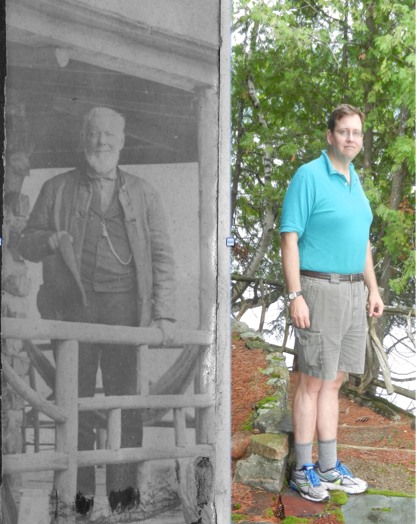
You see me here standing where my great-great grandfather George Hornell Thacher Sr. once stood on the porch of the family lodge built in 1867 on Thacher Island on Blue Mountain Lake.   The photo is not dated but given his aged appearance (no, the guy on the left), I believe it to be from the early 1880s.

My father spoke of visiting his uncle on the island as a young boy in the 1940s.   No Thacher has had the opportunity to walk the island since then. It had always been a dream of mine to visit my family’s first summer home. A dream fulfilled thanks to the hospitality of John and Janet O’Loughlin, whose family has owned the island for over two decades.

I am extremely grateful to John who, after discovering my writing, sought me out and extended an invitation for my family and me to visit their island.

The island holds a special place in the hearts of the O’Loughlins and their extended family.   Janet and her brother spent many childhood summers lodging at Potter’s.   She often visited the Anderson family, who owned the island at that time. She and her brother always fought over just which one of them would one day buy the island and make it theirs. In the end, it was Janet’s beloved, late brother who made the island part of their legacy.

Their family has lovingly restored and expanded the lodge.   The original walls of the 1867 lodge still remain within newly finished interior and exterior walls, noticeable by the almost one-foot-thick door jambs. Just as the original cabin remains, albeit hidden, on the island, I wondered what other traces of my family remained on Thacher Island.

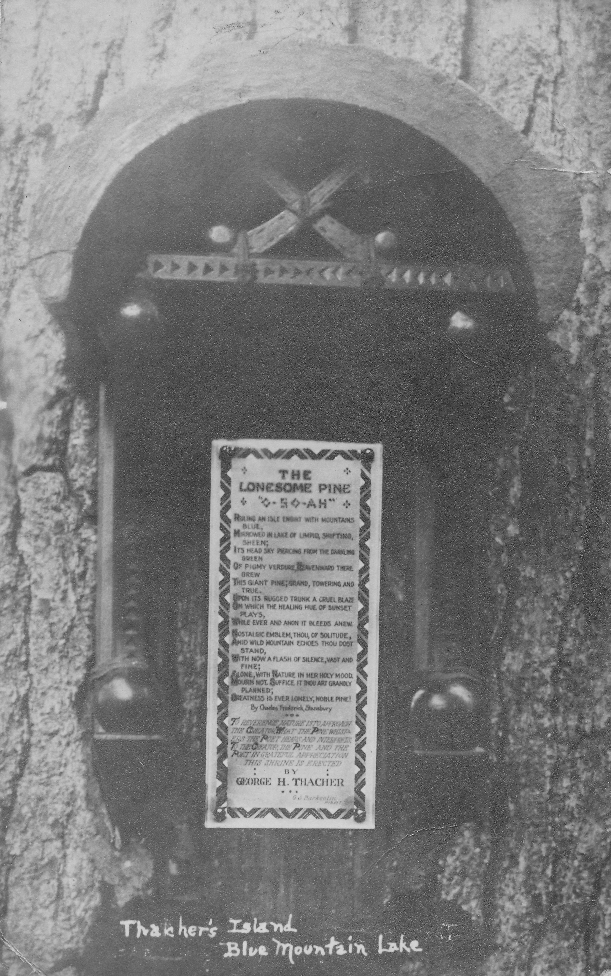
When I researched my family’s time on the island, I came across this interesting 1920 postcard showing a wooden plaque affixed to a tree.

Thacher lonesome pine postcard

Was this still there?

The postcard intrigued me because the lettering is too small to discern anything other than “The Lonesome Pine”. I assumed the meaning would be lost to posterity until I made a find in my cousin’s family photo album.

erecting

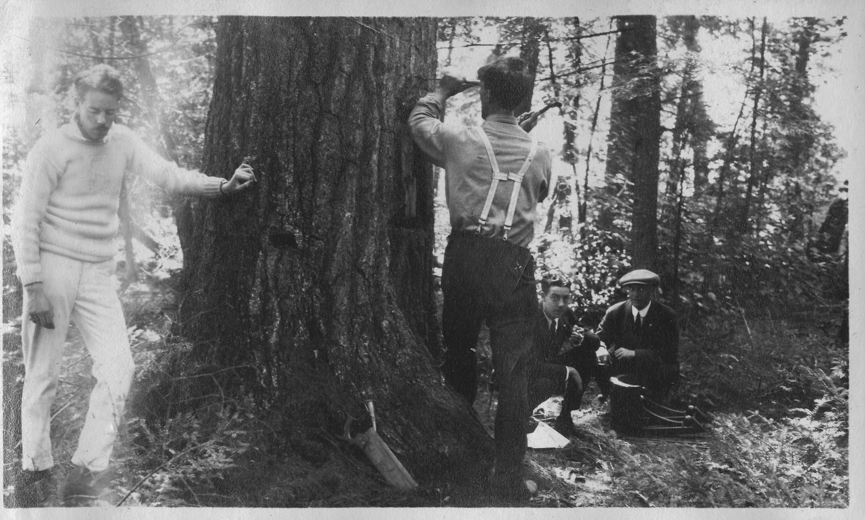
In this photo, four of the five Thacher brothers are seen erecting the shrine in September of 1919. My grandfather Kenelm is at left, GHT 3rd is hammering, and Edwin (whom some of you may know as Ebby T.) and Thomas are crouching on the right.

Another photo shows a close-up of the text of the shrine.

the poem

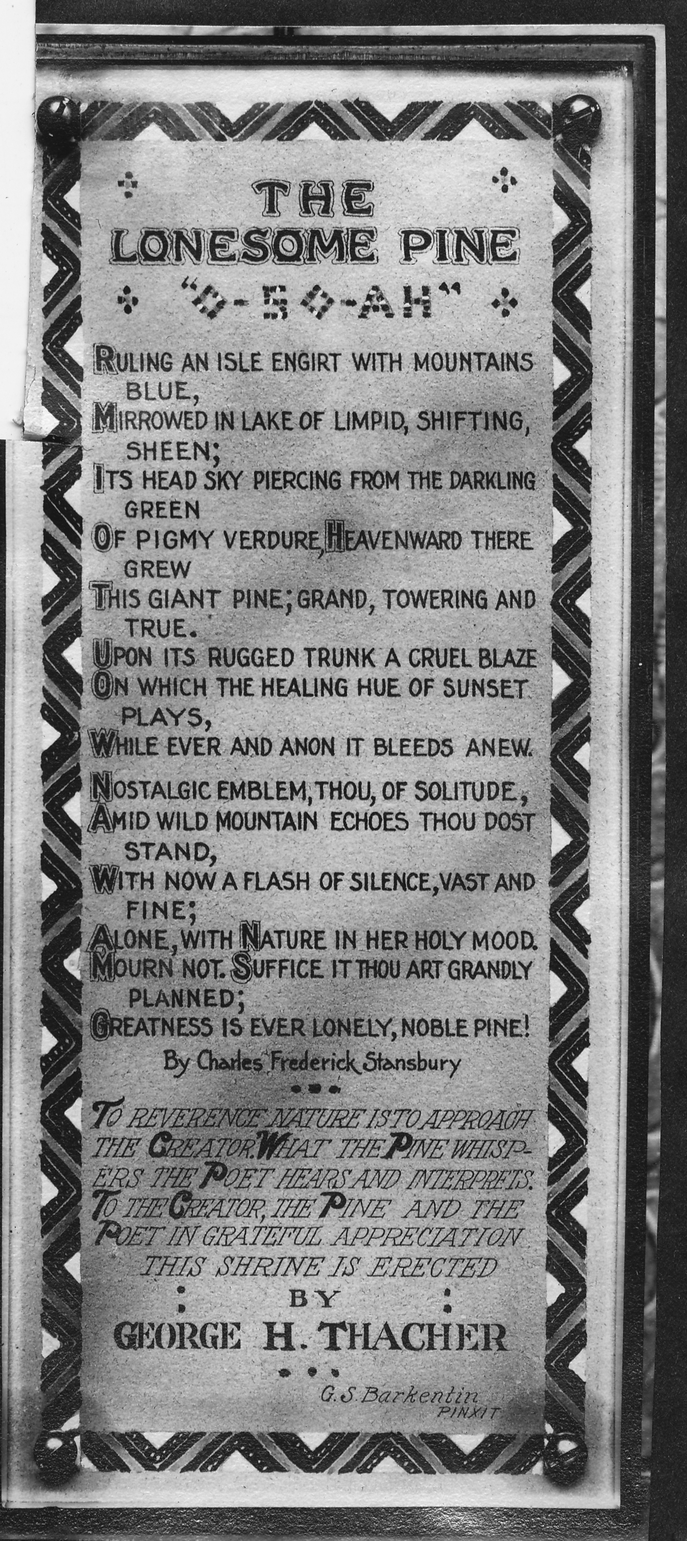
It is the poem “The Lonesome Pine”, written by Charles Frederick Stansbury.   The words of the poem evoke a tall pine tree on the island that towers over all the others.

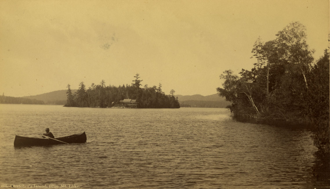
In this 1870s photo of the island by Seneca Ray Stoddard, one pine tree eclipses its neighbors by more than thirty feet, located about one hundred feet behind the lodge.

Thacher island lone pine

A different vantage appears to show the same tree not looking very healthy in a postcard from the 1930s.

Thacher Isle 1927-1940 AZO Postcard


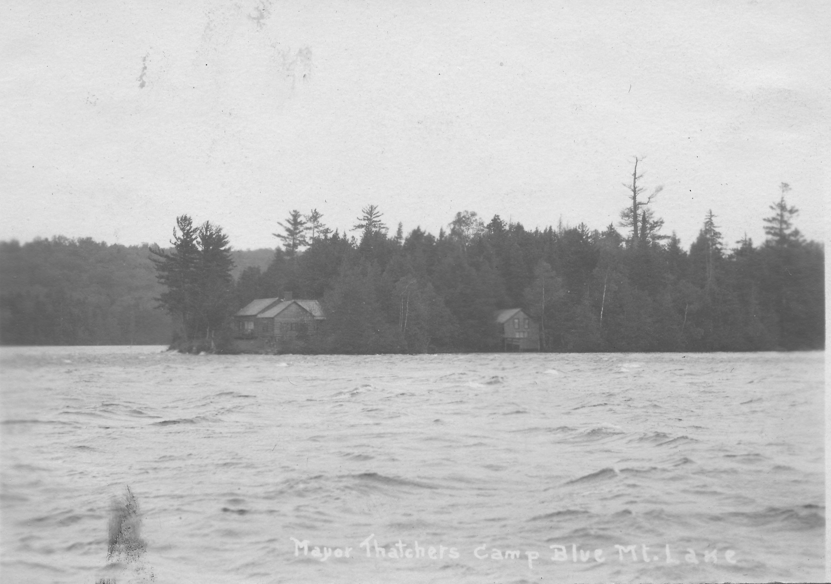
Alas, the tree is no more. Whether it succumbed to old age or the July 1995 microburst is not clear. John said that the island lost hundreds of trees in the microburst and it took him and the family weeks to clean up the destruction.

Momentarily dejected by this discovery, my spirits rose when John revealed that another part of our family legacy has indeed survived on the island. John mentioned having seen a photo in one of my earlier articles of John Boyd Thacher 2nd rowing a guide boat off the north shore of the island.

1922 JBT2 in guideboat

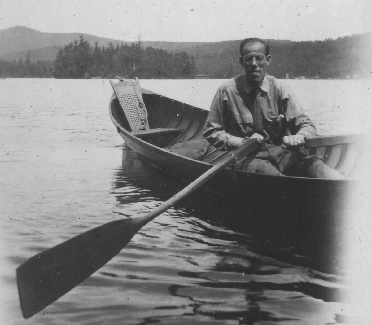
John led me along a path through the woods from the cabin to their boathouse.   As we entered the boathouse, John pulled away a large tarp and there she was.

JBT2 guideboat

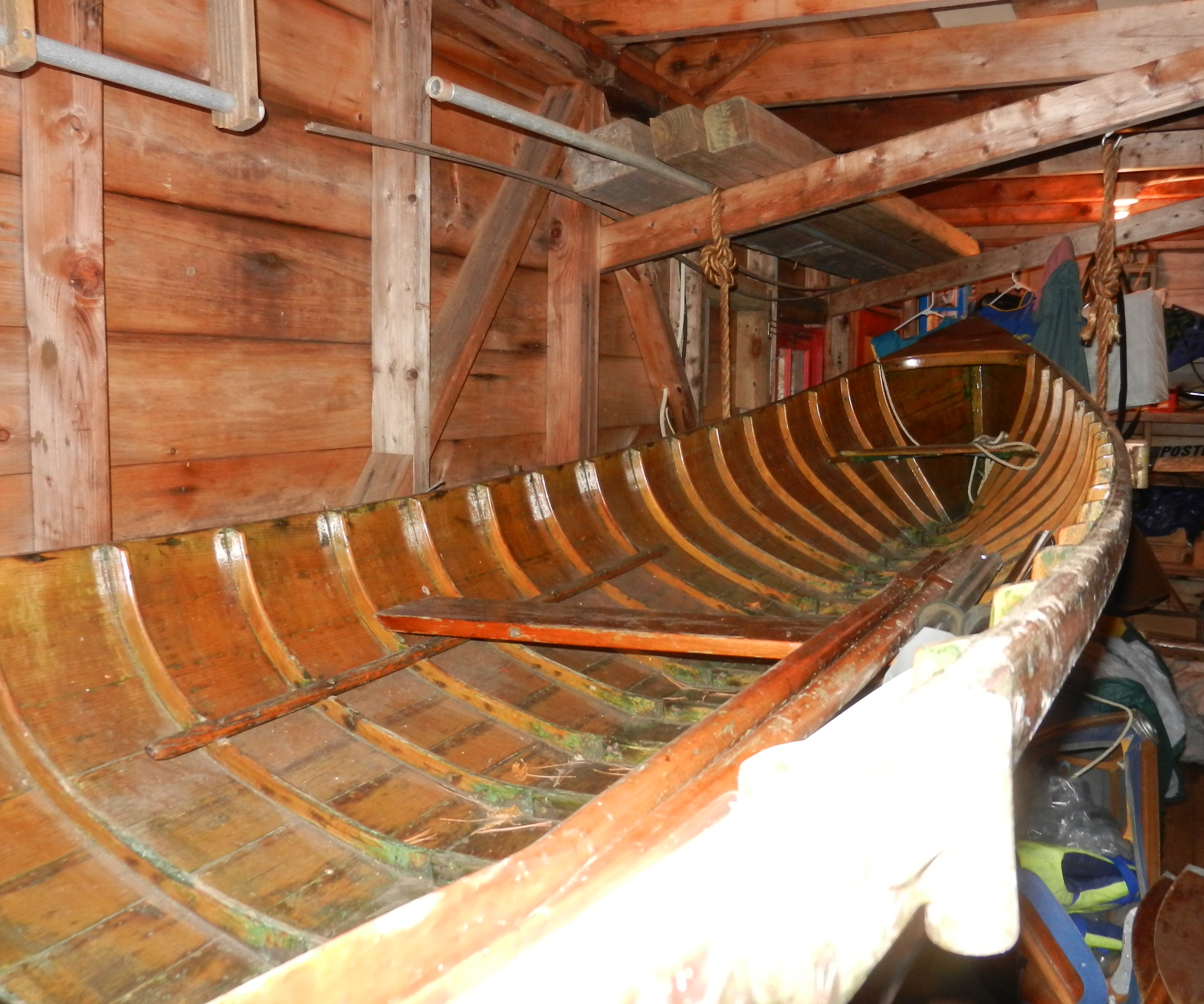
The photo of JBT2 is from 1922, but it could be that this guide boat dates back to the Thachers’ earliest times on the island in the 1870s.   (Perhaps a guide boat historian would like to take on the challenge of determining the age of this boat!)

As we prepared to leave the island, I realized that I misspoke when I said we were the first Thachers in over seventy years to walk the island’s paths. John and Janet’s two-year old grandson, who now explores these shores, carries on the island’s name as legacy to their family and ours.

The Case of the Indian Arrow Etched in Stone

My cousin Stephen Fitzpatrick showed me a mark that is chiseled into a rock just outside the front door of our family’s little red one-room cabin on Indian Point.

Screen Shot 2014-09-08 at 8.12.24 PM

The mark vaguely appears like an arrow but with a crosshair at the top instead of a point. Stephen applied an ink dye to the mark so it is more visible in this photo.

rock wide shot

Stephen remembers asking his mother about the mark, and she said that her father claimed it was there when he first came to the Point in 1910.

The mark itself is intriguing, but the mystery deepened when Stephen explained that the crosshair is actually a compass rose.   The large line runs almost perfectly north-south, and the smaller line is nearly east-west.

rock closeup

Curiosity piqued, I firmly slapped on my amateur sleuth’s cap.

I sent the photograph of the mark to Jim Vianna of the Colvin Crew to determine if it might be a surveyor’s mark. The Colvin Crew is a group of 140 surveyors dedicated to preserving the memory of Verplanck Colvin and rediscovering the exact locations of Colvin’s landmarks throughout the Park.   Jim dashed any thought of its being the work of a surveyor, suggesting that it simply was the result of someone with lots of time on their hands during a lazy summer day.

This led me to ask Warren Reynolds if he might have been the engraver. He had lived in the little red cabin over seventy years ago, when he was eight years old. He said neither he nor his family created the mark.

I consulted with John Fadden of the Six Nations Indian Museum to see if the symbol meant anything within the Iroquois culture. John did not recognize the mark as being the work of Native Americans.

When I say that the crosshair is a compass rose, it is important to note that it does not reflect true north; rather it is close to magnetic north. The difference between magnetic north and true north is called declination, and the position of magnetic north has changed over time.  Could the declination lead me to when the mark was made?

Today, the declination at Raquette Lake is 13° 34‘ west of true north.   A careful review of the photo that I had taken showed that the mark has a bearing of 5° west of magnetic north.   If we assume an uncertainty of one degree either side of this bearing, we could estimate that the mark was made at a time when magnetic declination was between 7° 34’ and 9° 34’.

I consulted a table of magnetic declination data from 1750 to 2010 for the latitude and longitude of Raquette Lake. It would appear that the mark was chiseled between approximately 1850 and 1880. Perhaps it is the work of Beach and Wood or the Thachers around the time of constructing their first cabin.   Or so I thought.

Given that my wife is an astrophysicist and a big stickler for scientific accuracy, this past weekend I went back and did more careful measurements of the bearing while keeping the compass elevated and level above the mark, rather than lying on the mark which is an uneven surface.   The bearing appears to be either dead on or less than one degree away from current magnetic north.  Not the 5° that my earlier photo showed.

While the declination in the last century has increased by about a quarter of a degree every year, it has not always been the case that the declination has been increasing. This chart shows that the declination at Raquette Lake has increased and decreased over time with a minimum declination of 5° 20’ west of true north. The dotted lines are one degree above and below the current declination.

raq mag declination

Prior to my grandfather’s use of the cabin starting in 1910, the last time the declination was within one degree of its current value was between 1600-1620. Could it be that the mark was made by the earliest of French Jesuit explorers of the region?

What a fantastic discovery! Or should I say “fantastical”, as in fantasy.   With my compass in hand, I made another discovery. I measured the bearings of the red one-room cabin’s walls. They too were aligned almost exactly north-south and east-west with today’s magnetic north.   We know the cabin was not built recently, nor was it built between 1600-1620.

I think my wife is correct when she says the conclusion is that 1) we have no idea of the accuracy of the magnetic compass that was used by the person who created this mark and 2) there is limited accuracy in the compass that I have been using to measure the bearing, thus leading to the conclusion that we can safely say the mark was made between 1600 and 2014.

If we were paleontologists, we would be raising a glass to toast right now. In this case, it goes to show that an armchair historian can get himself in a lot of trouble when he plays armchair scientist.

Of course, please do let me know if you recognize this mark.